|
For more information about walking along dismantled railway lines in Northamptonshire, go here. To see the rest of my website go here. My walks along Northamptonshire's dismantled railways in October 2003 |
The Brampton Valley WayThere is a car park near the southern end of the Way just north of Northampton. The route is mostly straight with not much in the way of cuttings or embankments, so it is a bit boring. There are two tunnels that you can walk through. Both seem to be about 400m and you can always see the end of the tunnel although they are not lit. I walked through both without a torch and had no porblems. There are alternative routes if you don't want to go through the tunnels. Near the southern end there is a railway for enthusiasts which is mildly interesting. There seem to be lots of carparks on the route. I imagine lots of people use it, but few walk all the way. 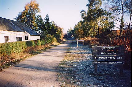
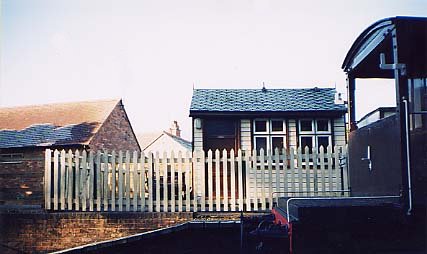
Part of the railway. Note the hut with the fish-scale tiles and the frost still on the roof nearby where it was shaded by the tree. 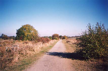
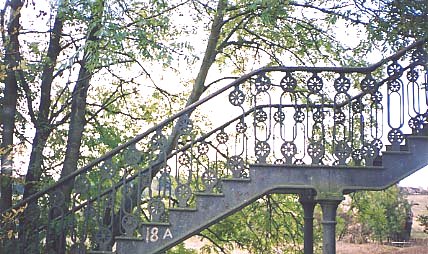
A beautiful stairway for crossing the line, now derelict and leading from nowhere to nowhere. 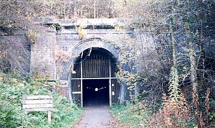
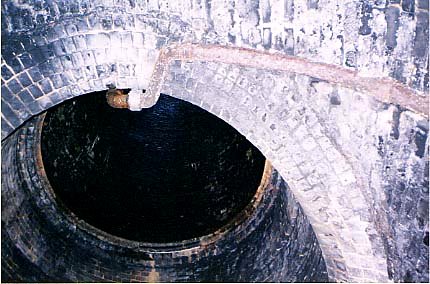
Inside one of the tunnels. There is no lighting, I used a flash. This is halfway where the air shaft is. |
Thrapston to BarnwellI had traced the course of the old railway line from Thrapston as far as the village of Wigsthorpe. I noted that the bed of the track from there on seemed as if it had been used as a dump for lots of rubble. I decided to follow the Nene Valley Way northwards. It took me across ploughed fields but then crossed the old track bed. To the south was a new house. Beyond the track bed seemed to have been planted up with trees. To the north was a driveway looking like part of someone�s garden. The Way continues through the village of Barnwell. I found the old station building near to the main road (A605). It is not impressive, but I could make out what looked like the remains of the platform. From here the track is under the main road as far as Oundle, but from it may be walkable as far as Peterborough. |
Rushden to ThrapstonNOTE: The old railway bridges over the river are being rebuilt. It will soon be possible to walk all the way along the dismantled railway from near Thrapston to Stanwick Lakes. From the northern part of Rushden I crossed the main road (A45). A path crossed an old disused railway line. This was the line from Wellingborough to Higham Ferrers passing through Rushden. Rushden was not on the Northampton to Peterborough line. The path curved round and joined Ditchford Road. I went north along the road; first there was a modern bridge and then an old stone bridge. On the north side of the river I went into the field on the right. The Northampton/Peterborough line track bed has been made into a road leading from Ditchford Road to the sewage farm. I walked parallel to it, along the Nene Way, and I noticed a digger excavating a long rectangular hole. After some consideration, I thought it must be the beginnings of a new channel for the river. NOTE: April 2004, it is a long narrow pond with narrow islands down the middle. As I got closer to the sewage farm the smell got worse. There was a weir, and a branch of the river going to the left, but it was dry. I left the Nene Way and followed a path going to the left. I was met by the sight and sound of beautiful poplar trees. After pushing through undergrowth I found myself in what seemed to be a railway cutting. It had willows and nettles growing in it, which together with the soggy ground made progress difficult. However, it seems that this is not the track bed, but what can only be described as a very wide ditch. I scrambled up the bank and through brambles to a path that follows the track bed north and east for miles. (From looking at the map, it looks as if there is an easier and quicker way to get to this point from Rushden.) To begin with it passes lakes to the left and right. There is a bridge with a sign suggesting that people should not cross, but I did. The next section of track bed is long and straight, except at one point where the track is like an embankment with flooded gravel pits on either side. Here, with water on each side, there are a couple of curves before the track bed continues dead straight. I remember that up till recently there were lorries carrying gravel along here, and there had been gravel pits before they had been flooded. Now all this work seems to have ceased. A bridge crosses the river, just before the road bridge that crosses the valley (A6) at right-angles to the track. The track goes under the road bridge and stops at a road (the lower-level crossing of the river and valley). On the other side of the road the track continues, but here work continued and access was denied. There had been big piles of gravel and sand here next to works, now they are gone and all this activity seems to be winding down. I went as far as I could. A deep channel had been cut across the track bed, to allow water to flow from one pit to another. Earth had been piled up along the route above the drop to create a barrier. After watching the workmen with their vehicles for a while hidden behind the barrier, I clambered down the slope to the left out of site of anyone. There was no vegetation here, just thick heavy brown and grey clay. Water was flowing down through the channel, which was about 15 feet high with steeply sloping sides. It was a strange sight. I thought about trying to jump the channel, and then climbing up the other side and continuing on my way, but that had its dangers. Instead I retraced my steps to a path that crosses the river at a footbridge where there is also a ford. This leads to Marsh Lane, where I rejoined the Nene Way. It goes along the north side of the river, and then, beside a large ploughed field, a footbridge crosses the river. Once across the river, I was on familiar territory, and I could walk along the old railway track almost as far as Woodford Mill. NOTE: I did this walk again April 2004 and the channel is no longer there. It is possible to walk this bit now although I think it is still 'out of bounds'. No need to walk along Marsh Lane. It looks as if the remaining vehicles on the site are landscaping it, so it may be open to the public soon. From Woodford Mill, I walked along the river to Ringstead, then over the hill on the footpath to Denford, as I have done many times before. Finally, I walked along the road from Denford to Thrapston. |