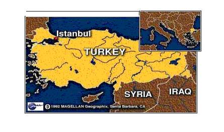
Figure 1
The location of Istanbul compared to Europe, the inland seas and the rest of
Turkey
Istanbul is located between 28º
01’ and 29º 55’ east longitude and 41º 33’ and 28’ North latitude. The
main part of the city, at the southeastern tip of Europe, is separated from its
suburbs in Asia by the Bosphorus straits, which flows from the Black Sea into
the Sea of Marmara .
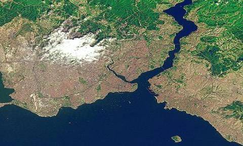
The city is the capital of
Istanbul province and is surrounded on the north by the Black Sea, on the south
and southwest by the Sea of Marmara, on the north by Kocaeli province, and on
the west by Tekirdağ province. The Bosphorus, a narrow strait that links the
Black Sea and the Sea of Marmara, separates. Istanbul’s European and Asian
sections. The European section is twice the size of the Asian section and
contains three-quarters of the city’s population. Asian Istanbul consists
mainly of residential houses and port facilities, (Ref:7)
Physical
conditions of Istanbul are what could be expected of a metropolis that is
centuries old. The developed land has slowly moved outward and upward. The
forest, reservoirs, and other natural resources are gradually being replaced by
housing, manufacturing, and commerce. The population is growing, illegal housing
is increasing, and physical conditions for a good
quality of life seem to be deteriorating – air, water, and land.
It is not possible to put
into one type the climate of region where Istanbul is completely located. The
city has different climate conditions from many areas of inhabitance because of
its geographical location and physical geography, (Ref: 15)
Three types of climate are dominant in Istanbul throughout the year.
These are north and south entering climates and mild climate. The climates
dependent on west and east directional winds are trivial. The most frequent of
the three is the climate observed when northern winds are dominant. There are
four phases according to the seasons; cold, hot, and two transitional phases:
One of which is long and the other. Snow does not linger for more than three or
four days. However, since snows are often followed by southerly winds that raise
the temperature and melt the snow, flooding can become a problem in winters that
normally experience a lot of rain. January and February are the rainiest months.
Spring can also be rainy but then summers are hot and sunny and can last from
May until November. Autumn can last until the end of December. The prevailing
northeast wind, or poyraz, comes from the Black Sea, giving way at times during
the winter to an icy blast from the Balkans known as the karayel, or Black Veil,
capable of freezing the Golden Horn and even the Bosphorus. The lodos, or the
warm, sultry southwest wind, melts the snow and can raise storms on the Sea of
Marmara. – The vegetation representative of a temperate climate.
The city’s vegetation is what would be expected in a temperate, damp,
sometimes rainy environment with hot summers. Within the city proper small green
areas are noticed in courtyards of mosques. Black Sea flora suited to a
temperate climate with regular rainfall has a distribution in Istanbul. Most of
the Black Sea region is forested, while meadowland predominates in the Marmara
region. Hazelnuts and hornbeam are the dominant species in the Black Sea region,
together with numerous other species such as oak, ash, chestnut, linden, maple,
alder, elm, meddler, cherry, bay and elder, (Ref: 16)
These mixed woodlands
extend from the coastal plains up to a height of 530 meters within the city
limits, and at the lower altitudes include wild roses, blackberry, privet,
firethorn, rhododendron, honeysuckle, boxwood and other shrubs.
The most typical
vegetation includes cypress trees and plane trees (Ref: 13)
 ISTANBUL
Figure 2. Distribution of forest in Istanbul
In Istanbul 35% of the green area is on Asian side (the
private forests excluded), which provides green space of 1.2 square meters per
person. 65 % of the green area is on European side of the city and provides 1.13
square meters per person. It is an extremely low ratio in comparison with the
average of all European cities. In terms of park to recreational space, the
ratio is even lower at 0.92 square meters per person (Ref: 16). Moreover,
city has special nature values
with different plant species of Europe and Asia continents, diverse habitats
with climate varying from cool and humid Black Sea to hotter Mediterranean
weather, and soil diversity and as well as a long history of traditional
agriculture.
The humid forests covering peninsulas on both sides are composed of deciduous species like oak, oriental beech and chestnut. Among the sand dunes found in Black Sea cost, the richest ones in terms of most rare plant species are present in Istanbul. Moreover, the last wide heath lands of East Europe are around Istanbul.
|
Normally Grove Forest(Ha) : |
61559 |
|
Demaged Grove Forest(Ha) : |
7369 |
|
TOTAL GROVE ORMANI (Ha) : |
68928 |
|
|
|
|
Normally Baltalık Forest(Ha) : |
154544 |
|
Demaged Baltalık forest (Ha) : |
15656 |
|
TOTAL BALTALIK ORMANI (Ha) : |
170200 |
|
|
|
|
open space (Ha) : |
294136 |
|
Total area(Ha) : |
239128 |
|
General area(Ha) : |
533264 |
|
Forests rate(%) : |
44,8 |
Terkos and Kasatura Forests, Upper Bosphorus Strait, Hadımköy to
Kemerburgaz Grasslands and heath lands, Sahilköy to Şile Dunes and Forests and
Belgrad forest are important green places of Istanbul (Ref: 7).
FOREST FIRE IN ISTANBUL
Istanbul as the biggest city of Turkey, as a window into the world, has always been attractive for the interior migrations. Istanbul recorded a population of nearly 1 million inhabitants already in the 9th century. After the Second World War, its total population was still about one million. In the past four decades the population growth has begun to increase rapidly and outlying villages become incorporated into the metropolitan area.
|
Place |
Pop. 1997 |
Pop. 2000 |
Pop. 2004 |
|
Alemdağ |
|
|
|
|
Çatalca |
14.9 |
|
17.7 |
|
İstanbul |
8260.4 |
8803.5 |
9631.7 |
|
Şile |
|
10.3 |
11.4 |
|
Bahçeköy |
|
|
|
|
|
|
|
|
Table 2. Population of districts
By 1994 more than 65 percent of Turkey's population lived in cities. The urban population has been growing at a rapid rate since 1950. The phenomenal growth of Istanbul since the 1950's has been the result of large-scale migration of people from the villages. By 1980 up to 60% of the residents of Istanbul lived in illegal settlements, known as gecekondus ("built overnight").
In 1994 Istanbul's official estimated population was 7,615,500, after 6,6 million in 1990. Within the Istanbul metropolitan area, there has been considerable migration from crowded central Istanbul to the Asian side of the Bosphorus and also to various suburbs (Ref 13) Due to the process of active interior migration experienced within very short period of time (quarter of a century) and so to the chaotic urbanizations, Istanbul is extremely worn out. Chaotic settling occurred due to the demand of the arriving and naturally increasing population has almost destroyed green plantations. Istanbul, once surrounded by forests, has lost most of its greenery due to unplanned and speedy urbanization (Dökmeci and Berköz, 1999).
Over the past few years, forested areas have decreased all over the world in result of fire in the developing countries, as well as due to the further industrialization of the developed countries. These developments are observed almost all over Turkey, and especially in the Istanbul area where the population has increased to 12 million in the last few years, (Bilgili and Sağlam, 2003).
Fire is a common feature of Mediterranean landscapes, and has a pervasive influence on its forests and their management. Recent statistics indicate that the region is experiencing an ever-increasing wild land fire problem, which can be attributed mainly to the vegetation associations (fuels) coupled with weather conditions and forest–human relationships in the region. Thus, fire behavior prediction is of crucial importance in fire, forest, and land management in the region (Bilgili and Goldammer, 2000),
The properties of fire are also affected by characteristics of vegetation, such as the quantity, chemistry, moisture content, and size distribution of fuels. Fire regimes will often differ between riparian areas and uplands because of differences in geomorphology, hydrology, vegetation, and microclimate. Land use and management have frequently altered characteristics of riparian areas, including the presence of surface water, ground water tables, floodplain topography, and biotic diversity and productivity. Cumulative effects of human disturbance may also strongly influence fire properties and regimes in riparian areas, and these factors are likely to be most pronounced during periods of drought and under conditions of extreme fire weather. Effects and properties of fire cannot be isolated from human activities, including water use and management and anthropogenic disturbances (Çanakçıoğlu and Ozkazanç, 1997). There are many reasons of destruction of forests Forest fire is the most effectual of these reasons in Turkey as in the lots of other countries of the World. Also, there are many reasons of forest fire too. However, we can classification the reasons of forest fire following:
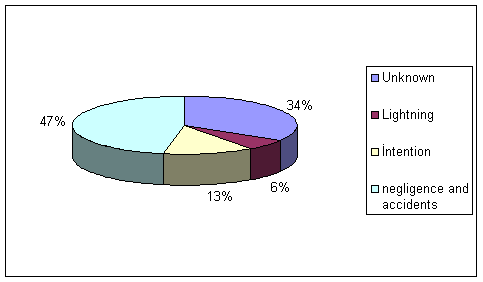
Chart 1. Reasons of forest fire
Example of negligence and accidents
· Because of weapon application, (Ref: 18)
In Istanbul most of forest fires occurs because of negligence.

Chart2. Reasons of forest fires
This chart shows the reasons of forest fire in all Istanbul. Thus, 46% of forest fire occurs because of carelessness and 3% of forest fires occur because of accident.
METHODOLOGY
To begin, I used distribution forest map of Istanbul. With a basic map of Istanbul that show the forest fire districts. With a basic map of Turkey that show the special protection area for forest fire boundaries. A map of Istanbul that show the trees types of Istanbul, and a basic map that show the forest types of Turkey and Istanbul are used in study. These maps were put into Arc view as Jpegs.
Three
types of secondary data are used in this thesis. These are, demographic data
include population of districts, numbers of fire based on years, a basic map of
Istanbul with the boundaries of fire locations, and a basic map of Istanbul
showing forest cover. Several graphics are used in this thesis to show
demographic data.
RESULT
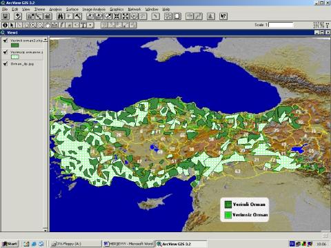
Figure 2. Vegetation types of Turkey
26 % of Turkey is covered with forests. These natural values
can be inherited to new generations only if the number of protected areas such
as national parks, nature conservation areas, and nature parks are increased.
Only 2 % of Turkey's forests are under protection at the moment, (Ref: 17). This
figure shows the vegetation types of forest. Dark green refers to fertile forest
and light green color refers to poor forest of Turkey.
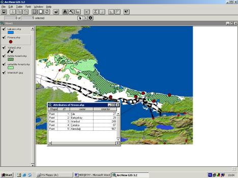
Figure 3. Forest situation map
Istanbul vegetation zones can be classified in to two groups.
Forests are the main vegetation in and around Istanbul. There are two forests on both sides of the Bosporus, named “Belgrade Forest” at the European side and “Alemdağ Forest” on the Asian side. The dominant tree species is the oak (Ref: 17).
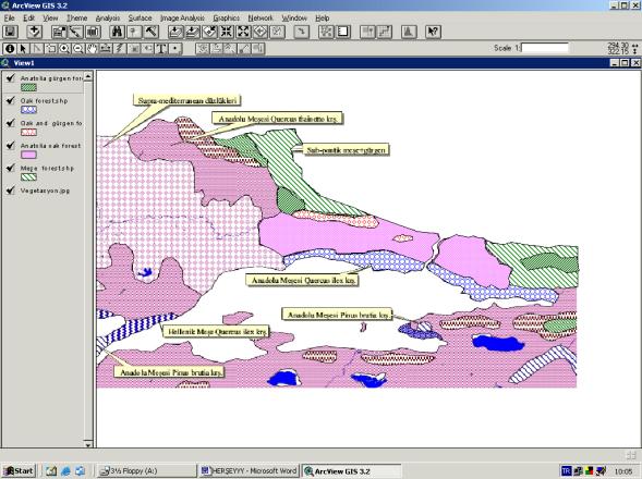
Figure 4.
Natural vegetation cover
44.8 % of Istanbul covered by forest. This map shows the types of vegetation cover in Istanbul. Dominant types vegetation are; Anadolu meşesi (quercus-ilex), sub-pontik (gürgern and meşe), Anadolu meşesi (quercus frainetto ), Anadolu meşesi (pinus brutia ), (Ref:17).
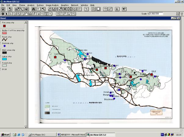
Figure 5. General distribution of forest and management directorships
There are 5 forest management directorships in the Istanbul. These are Istanbul, Bahçeköy, Şile, Alemdağ and Çatalca, (Ref: 19). This map shows locations of these directorships.
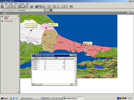
Figure 6. Forest management directorship boundaries map
This
map shows the boundaries of 5 forest management directorships.
2.Çatalca: Total area of this directorship is 255.462 hectare. And forest is cover 42% (107.707,5 hectare) of total area, (Ref: 17)
3. İstanbul: General area of Istanbul management directorship is 83324.0 hectare. Forests cover 21367.0 hectare of total area and 61957.0 hectare of total is poor (no forests). 13559.0 hectare of forest is grooving forest and 78080 hectare is baltalık forest, (Ref: 17)
4. Şile: Total area of directorship is 78215 hectare. 58540,5 hectare of total area is forests and 19675.5 hectare is open area. 75% of total area is forest. 6084 hectare of forest area is grooving forest and 52456.5 hectare is baltalık forest, (Ref: 17)
5. Alemdağ : Total area of management directorship is 107896 hectare. 42000 hectare is forest and 65896 hectare is open area. 43% of total area is covered by forest. Also, 16957,0 hectare of total forest area is grooving forest and 6538.0 hectare is damaged forest, (Ref: 19)
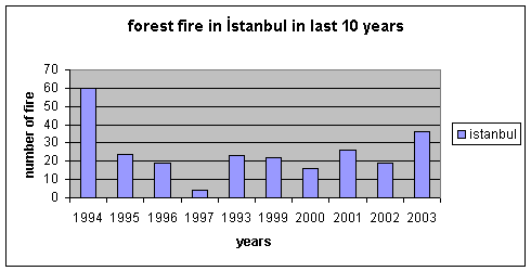
Graphic 1. Number of fire depends on year in Istanbul management directorship
According to graphic1 there were 60 forest fire occurred in 1994.And most of forest fire occur in this year. Minimum forest fire was occurred in 1998.
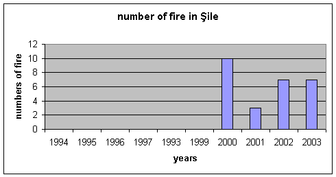
Graphic 2. Number of forest fire depend on year in Şile management directorship
According to this graphic, maximum forest fires were occurred in 2000. And minimum fires were occur in 2001.There were 10 forest fire occurred in 2000 were 3 forest fire occurred in 2001.
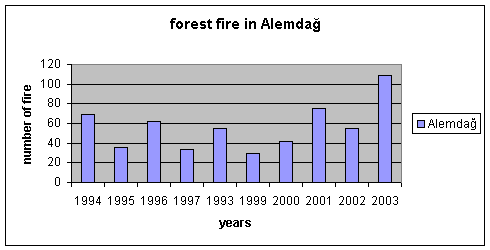
Graphic 3. Forest fire in Alemdağ management depend on years
According to graphic, maximum of forest fire occurred in 2003, and minimum forest fire occurred in 1999.
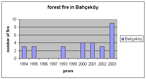
Graphic 4. Forest fire in Bahçeköy management depend on years
Graphic 4 shows that, there were 9 forest fire in 2003 and 3-forest fire in 1994,1995 and 2002.
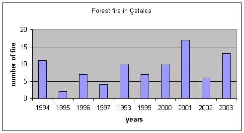
Graphic 5. Forest fire in Çatalca management directorship depend on years
According to graphic 5, There were 18 forest fire occurred in 2001 and 3 forest fire occurred in 1995.
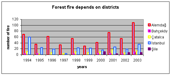
Graphic 6. Forest fire in 5 districts
This graphic shows 5 forest fire management directorships and number of forest fire that were occurred in last ten years. According to graphic most of forest fire occurred in Alemdağ in 2003. And, there is no forest fire in Şile in 1994,1995,1996,1997,1998 and 1999.
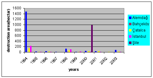
Graphic 7. Damaged area in forest management directorships
Graphic show that, about 1500 hectare area was damaged during the forest fire in Alemdağ in 1994.1000-hectare area was damaged during the fire in Şile in 2001.
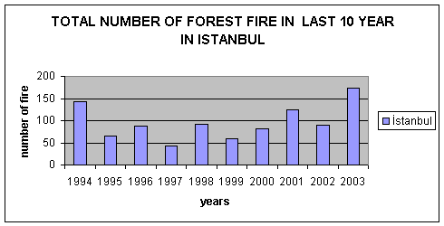
Graphic 8. Total number of forest fire in last ten year
According to this graphic, maximum forest fire occurred in 2003 and minimum fire occurred in 1997.
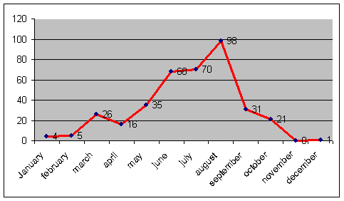
This graphic shows the number of forest fire depends on month. As we see on the graph 9, most of forest fires occur in august. Most of forest fires occur in the summer months because of high temperature of İstanbul. In the summer month the temperature of Istanbul is about 20-29 degree. On the other hand less amount of forest fire occur in the cold months of fall and winter. Because in this season the temperature of İstanbul is 3-13 degree, (Ref: 17)
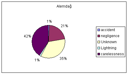
Chart3. Reasons of forest fire in Alemdağ
According to chart, most of forest
fires are result of carelessness and 35% of reasons of forest fires are unknown.
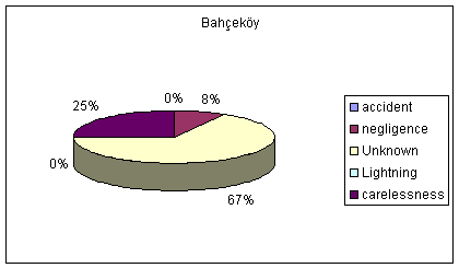
Chart4. Reasons of forest fire in Bahçeköy
Reasons of most of fires are unknown and the 25% of forest fire occurred because of carelessness.
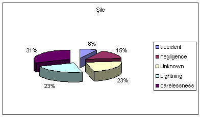
Chart5. Reasons of forest fire in Şile
According to that chart, in Şile 31% of forest fire occurs because of carelessness. And 8% of forest fire occurs because of accident.
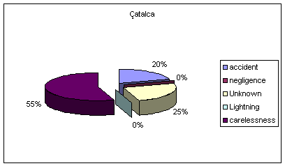
Chart6. Reasons of forest fire in Çatalca
A high percentage of forest fire occurs because of carelessness in Çatalca and there is no any forest fire that occurs because of lightning in Çatalca.
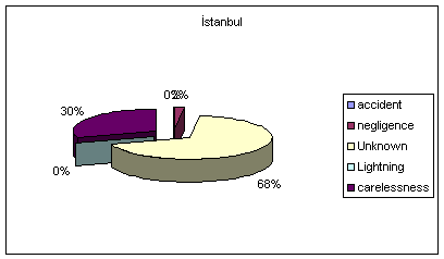
Chart7. Reasons of forest fire in Istanbul
Chart shows that, the reasons of 68% of forest fires are unknown and 30% of forest fires occur because of carelessness.
There are a lat of reasons of forest fires. These are accident, negligence, lightning and carelessness. In Istanbul, an important reason of forest fire is carelessness that is caused by human activities. Picnic and cigarette are two important of these activities.