View from above -
    Hunter Field

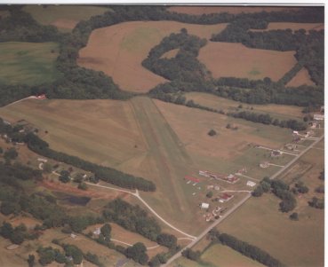
Aerial View
Hunter Field


COLUMBIA
Hunter (STOL)
ELEV. 650'


Location Identifier: 06TN

Coordinates: 35.42.N, 86.57W

From City: 7 Miles NE

Runways: 5/23 2000' x 100' Turf

Lights: Low Intensity on Request
(615-486-2336)

Traffic Indicator: Tetrahedron & Windsock

Radio Facilities: NO > CTAF 122.9

Weather: FSS-BNA
(800-342-5802)

Accommodations: In Town

Operator: Hunter Field, L.L.C.

Manager: W. A. Hunter, Jr.
615-486-2336


Attended: Weekends

Fuel: MOGAS


Repairs: None

Storage: T-Hangers, Tie-down

Transportation: Taxi


Phone: None on field
Navaids: BNA (VOR) 114.1 MH 205 deg. , 28 NM to Airport
WKRM (BS) 1340 KH 1 KW -047 deg., 6 NM to Airport

Or check out the Airnav listing:


AirNav: Information on HUNTER STOLPORT

Return to the Hunter Buzzards Home Page
Hosted by www.Geocities.ws

1