|
Equestrian
Parking at the Dry Creek Recreational Trail Experience (Cont’d) |
No
camping will be permitted at the parking lot. However, there is
a small primitive horse camping area about ¼ mile away, accessible
by crossing the nearby East Armuchee Creek on a Forest Service road.
The parking lot fulfills the second part of what I envision as a four-part recreational trail experience. Some people may consider the Dry Creek Recreational Trail Experience (my name only) as a dream, but I do think it will happen within the next several years. The first existing part is the nearby Georgia Pinhoti Trail (GPT). The GPT lies within about ½ mile from the parking lot, currently reachable on a gravel Forest Service road. The GPT offers about 32 miles of end-to-end uninterrupted National Forest trail from the Dry Creek area to near Dalton, GA. This superb trail is provided for equestrian, mountain bicyclist, hiker, and other non-motorized user enjoyment. Volunteers who support the Georgia Pinhoti Trail Association (GPTA) and the U.S. Forest Service maintain the GPT in this area. What
are the 3rd and 4th parts of the Dry Creek Recreational Trail Experience?
The third part is an environmentally sound 12-15 mile loop trail
system for all non-motorized users that connects the parking lot,
the GPT, and a nearby equestrian camping area. Naturally the equestrian
camping area is the 4th part of this concept. A few unofficial loop
trails already exist in the Dry Creek area. Some of these trails
are good and others are neither environmentally sound nor in safe
condition for public use. A well-designed loop trail system for
Dry Creek has been proposed but no Forest Service action may be
taken during the current moratorium on new trail development. As
many folks may not know how to find the Dry Creek area, extensive
directions are provided below. From
Villanow, travel south on 705 for about 10 minutes to arrive at
the area.
From US 27 at Gore, travel north on the Gore-Subligna highway for
8.1 miles to the village of Subligna. Turn right on the East Armuchee
Road (this is also the Subligna-Villanow Highway/ Route 705) and
drive about three miles to the Dry Creek area. |
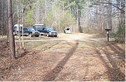 There are additional locations along the Dry Creek area Forest Service
(FS) roads (FS 226 and FS 310) where one may park one or more equestrian
rigs. About ¼ mile before reaching the new parking lot is
a location where at least four rigs can be parked. Likewise similar
space exists beside FS 310 where it nears the East Armuchee Creek
and the GPT creek crossing (shown in the photo at left).
There are additional locations along the Dry Creek area Forest Service
(FS) roads (FS 226 and FS 310) where one may park one or more equestrian
rigs. About ¼ mile before reaching the new parking lot is
a location where at least four rigs can be parked. Likewise similar
space exists beside FS 310 where it nears the East Armuchee Creek
and the GPT creek crossing (shown in the photo at left).