moving to
http://mclane65.tripod.com/jefferson.html
enjoy the twinkle in our eye
our tongue firmly affixed to our cheek
our "politics" is, after all, a lot of fun
State of Jefferson
northern California ~ southern Oregon
The State That Almost Seceded
"John Sutter's `Republic` existed mostly in his own mind"
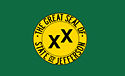
The flag does not thrill me, but it's Sutter's bequest
now claimed for our mythical (51st) state of Jefferson
Pacific Republic
Jefferson is a mostly rural area of Southern Oregon and Northern California. Several times during the 19th, 20th and 21st centuries there have been attempts to establish the area as a separate state. This region on the Pacific Coast is the most famous of several that have sought to adopt the name of Thomas Jefferson, the third President of the United States; the name was proposed in the 19th century for Jefferson Territory, as well as in 1915 in a bill in the Texas legislature for a proposed state that would be created from the Texas Panhandle region.
Dominated throughout history by the Sureño, the Southlanders, of the Los Angeles region, California has seen its interests overlooked, its rights ignored, and now, its water appropriated by the over-represented southern Californians riding high in the saddle, politically.
As northern Californians, we look back to such Norteños as Vallejo and Sutter, who sought to balance out the dominance of the populous Los Angeles rulership of all of California. Sutter at one point envisioned a "Pacific Republic" joining our part of California and Oregon. He even hoped to welcome Mormons to migrate here. In the old world, rumors of the immediate success of his exploits led to stories of Sutter being the emperor of California, [Kaiser von Kalifornien]. Sutter himself has been called mercurial, pugnacious, vain, arrogant, ambitious. Truth be told, Sutter was indeed human -- all too human. He saw that the true wealth of his inland empire was its people, its human treasure. Accordingly, he eagerly welcomed immigrants from the United States.
Additionally, John Sutter, like Jefferson, had an unwavering appreciation for agriculture as the engine of economic potential and growing prosperity. Like Jefferson, Sutter welcomed the common man, the yeoman individualist in search of personal betterment. Sutter's empire may have lasted only a few years, but his dream was surely not off base. Jefferson would have approved.
wikipedia
Bisected by a trade and travel route which came to be known as the Siskiyou Trail, the region of the proposed State of Jefferson was one of the last areas of North America to be explored by Europeans, Spanish first, and then Americans. The first Europeans to California were Spanish-speaking ones who travelled up and down the river we call the Sacramento (they called their Río Grande, later the Buenaventura), trading with local native peoples.
Non-Native (Anglo) American explorers did not enter the area until the 1820s, these were the famous mountain men.
(See Jedediah Smith, pathfinder). Permanent Anglo-American settlement in the area did not occur in our area until 1844 by Pierson Barton Reading (pronounced Redding), an immigrant to Alta California from the United States. See History.
The area to the northeast was also the site of the last battle fought in North America where the Native Americans used only bows and arrows (at Castle Crags), and was the site of one of the last significant rebellions by Native Americans (the Modoc War).
History
In 1852, at the first California state legislature, a bill was introduced to create a "state of Shasta" encompassing much of the area known as Jefferson, including the Shasta Cascade.
Two years later, a separate movement began in southern Oregon. A proposal to create such a state was presented to Congress and remained open until Oregon was granted statehood in 1859.
In October of 1941, the mayor of Port Orford, Oregon, Gilbert Gable, announced that the Oregon counties of Curry, Josephine, Jackson, and Klamath should join with the California counties of Del Norte, Siskiyou and Modoc to form a new state, which was later named Jefferson. That flag, the Dos Equis flag, caught on briefly, but the local rush of excitement as quickly dissipated, nor was it really taken with more than a grain of salt.
Gable proposed creating this new state to draw attention to the condition of the state roads along the Oregon-California border, which at the time were oiled dirt roads that became impassable in rain or snow, and handicapped economic development. As local historian Jim Rock explains, "It was more publicity stunt than serious secession movement at that point. After all, under the U.S. Constitution, they had to get the approval of Congress as well as the legislatures of both states."
Gable's act found sympathy throughout the region, who perceived their state legislatures as indifferent to their needs. Siskiyou county especially embraced the cause: the county seat Yreka became the provisional capital, where in November, 1941 county representatives met and selected the name Jefferson for their state, in commemoration of Thomas Jefferson, the nation's third president.
While inhabitants in Lassen and Shasta counties in northern California flirted with joining the secession movement, only the counties of Curry, Siskiyou, Trinity, and Del Norte actually endorsed the idea.
On November 27, 1941, a group of young men gained national media attention when, brandishing hunting rifles for dramatic effect, they stopped traffic on U.S. Highway 99 south of Yreka, and handed out copies of a Proclamation of Independence, stating that the state of Jefferson was in "patriotic rebellion against the States of California and Oregon" and would continue to "secede every Thursday until further notice." Looking back on those days, we can speculate that the double cross, dos equis flag was inspired by the double edged resentment against BOTH southern California and northern Oregon.
The secession movement, such as it was, came to an abrupt end, though not before John C. Childs of Yreka was inaugurated as the governor of the State of Jefferson [1]. The first blow was the death of Mayor Gable on December 2, followed 5 days later by the bombing of Pearl Harbor on December 7.
As if that were not enough, Los Angeles and the southland got even more clout in the Supreme Court's (1962) Baker v. Carr decision, robbing power in the legislature from rural areas, and giving even more power to the big megalopolis to the urban South state. You may smile at our idea of a "Pacific Republic" of our own. Indeed, we are fun-loving and hope to provoke thought ourselves. But also, while you smile, please ponder and consider these issues.
As described in an April, 2003, American Journalism Review article:
The "state" is diverse politically, with a mixture of conservatives and liberals. Many share the Westerner's common disdain of government and politics. "Politicians and diapers need to be changed often for the same reason," reads one bumper sticker. And many also share a desire to hang on to the landscape that draws both residents and tourists to an area that stretches from the stunning Oregon coast to ethereal Crater Lake and down to California's towering Mt. Shasta.
The region retains this identity reinforced by institutions such as Jefferson Public Radio.
Today there are more talks of creating the new state, mostly only half serious. Many citizens of "Jefferson" feel threatened by National Marine Fisheries Service's plans to create fish hatcheries along the Klamath River, as well as creating a buffering zone along the river. This buffering zone would oust many people from their homes and even demolish an entire town. Meanwhile, others in "Jefferson" have embraced the idea of the entire Pacific Northwest breaking away from the United States and Canada to become its own country, Cascadia. A large barn off of Interstate 5 north of Weed, California has "the State of Jefferson" painted on the roof. Indeed, some local drivers have license plate frames declaring themselves citizens of Jefferson.
Jefferson is commemorated by the State of Jefferson Scenic Byway between Yreka and O'Brien, Oregon, which runs 108 miles along California State Highway 96 and U.S. Forest Service Primary Route 48. See Museum of the Siskiyou Trail
The State of Jefferson
The dos equis, double cross flag
Tidbits
Ian Jones (Siskiyou Schools) has put together one of the best troves online of facts on the historical roots of the "State of Jefferson" as well as later incarnations of the notion, even the dos equis, double cross flag. While none of this ever "materialized" in a real world sense, it's still all a lot of fun.
Sam Taylor on Loose Gravel (bikers) web space has done an outstanding job informing and entertaining regarding the State of Jefferson. See it here.
And here's an interesting link on the State of Jefferson.
And here's another on the brief existence of (don't say wannabe) the double X-rated State of Jefferson, 1941.
Yazziegirl (Kerry Tingley) presents a very attractive scenic photo-tour of the State of Jefferson See it here.
The state of Jefferson: The dream lives on (Museum series, Unknown Binding)
Publisher: Siskiyou County Museum (January 1, 1999)
by James T Rock;
ASIN: B00073DC9Q
Do We Entertain You?
The 'Humorist'
Bob Shepherd

Bob Shepherd with some pizza pals, 2008
my_space: Stay thirsty my friends!
thanx 2 wikipedia