KOTA KINABALU: It's
official - Low's peak is not the highest point on Mount Kinabalu.
That distinction now belongs to an adjacent peak - Victoria - 87 years to the day that the Learmonth expedition commissioned by the British North Borneo Company put Low's Peak at 4,101 (13,455ft) on 25 June 1910 using the sextant from a vessel off Kota Belud.
The latest measurement using Global Positioning System technology employing satellites for utmost accuracy was announced by Chief Minister Datuk Yong Teck Lee on Low's Peak at Kundasang at 9.30am Wednesday 25 June 1997.
The new initiative comes in the wake of the heighting of several other points on the mountain, especially Low's peak, which yesterday was found to be 4,093.372m - some eight metres or 24 feet lower than the previous height.
The reduced new height is contrary to what many had believed and expected that Low's Peak was growing particularly when geologists claimed that it was growing at the rate of five milimetres a year.
However the real height of Victoria's peak, itself, will have to wait for a new expedition ordered by Chief Minister Datuk Yong Teck Lee at the summit.
Yong said the sheer steep rock face of the nation's new highest peak is hazardous for normal climbers and members of the recent Mount Everest expedition may be given preference if they were interested in assisting the State Government establish its official height.
A GPS placed on a small plateau adjoining the horn of Victoria Peak
(see picture) placed its height during the current exercise at 4m higher
than Low's Peak.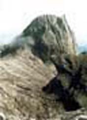
Director of Lands and Survey Sabah Osman Haji Jamal said the "horn" of Victoria Peak alone is estimated to be a least 10m higher.
He said two members of the expedition, Robert Cheng of the Department and Robert New, a mountaineering buff, were unable to place a GPS on the summit of Victoria to officially establish its height because it's tip is the size of a dinner plate.
"Moreover, there is a danger of a potential climber falling into the vast Low's Gully which the peak overlooks.
"Cheng managed to place the device on the plateau adjoining the `horn' instead and this is how we manage to establishe that even the plateau alone is 4m higher than Low's".
Osman said by their reckoning, the approximate height of Victoria complete with the "horn" should be not less than 4,107m. "This is what the future expedition will ascertain," he said.
Yong who climbed to Low's peak with 70 others, including four blind and four mentally handicapped persons, to announce the new height of Low's Peak said despite the nominal decrease in its height, it is still the highest accessible point for climbers at Kinabalu.
He did not think it would deter tourists and other climbers from going to the summit to enjoy a panoramic view.
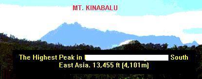
Mount Kinabalu would continue to remain Sabah's main attraction, being the highest mountain in Malaysia and the region that hosts endemic flora and fauna.
He braved a heavy mist near the summit and both his ascent and descent was virtually reduced to mere steps at a time with the aid of a stick when it became unbearable for his legs.
He set off for the summit with the climbers at 4am and returned to the starting point at park headquarters at 6.30pm.
Yong also commended the RTM crew accompanying the expedition for the "live" coverage nationwide, especially with their heavy equipment, from the summit.
He noted it was the first "live" broadcast from the summit.
A parks official said later he is believed to be the only Sabah CM to have climbed up and down Mt Kinabalu without using helicopters either way.
The historic event organised by the Institute of Surveyors Malaysia Sabah branch was also telecast live over RTM1. The main sponsor for the event was KFC (Sabah) while Daily Express was the official media sponsor.
Event Organising Chairman Ho Kin Wong said factors considered in undertaking the project included the fact that the earlier heighting of Low's Peak was done using outdated methods.
"Since heighting through satellite technology is now available and ensures greater accuracy, it was deemed timely to undertake a definitive heighting exercise," he said.
Sabah Parks Director Datuk Lamri said the height of Low's Peak will be amended on certificates of climbers once he receives the official notification from ISM Sabah.
Various changes may have to be made in tourism brochures, magazines and school text books and the new heights would also be made available on the internet.
| TOP PAGE | SABAH PAGE | F Y HO'S HOMEPAGE |