GEOLOGY & GEOPHYSICS
Home | Infra Red

Geology : Geo + logos = Study of the Earth
Science that studies the succession of the features and geographical characteristics that the earth surface, from the moment when the litosphere first consolidated to our days.
Subdivisions: Cosmology, Paleonthology, Structural Geology, Petrology, Geomorphology, Physiography, etc.

The 5 Stratigraphic Geological Principles
* Correlation: if a fossil of the same kind is found in two different places, the strata belong to the same period
* Dualism: The phenomena at the present time explain the past
* Superposition: the superior strata are later than the inferior ones
* Of Faunistic Succession: the strata can be distinguished because of its associated fossils
* Of Original Horizontality: the sedimentary strata are, originally, horizontals

More...

Deformation and permeability of aggregated soft earth materials (Oct 06)
C. G. Eggers, M. Berli et al
This study develops a framework for modeling deformation of individual pores in elastoviscoplastic earth material accounting for the effects of evolving pore size and shape on material hydraulic permeability. We describe the velocity field of a fluid within deforming pores of hypotrochoidal cross-sectional areas as a function of remote stress or deformation and elastoviscoplastic material properties using finite element analysis. We find that pore permeability decreases with increasing stress and deformation. Pore cross-sectional areas are mainly reduced in size while the shape remains constant.
More...

.

Incipient axial collapse of the Main Cordillera and strain partitioning gradient between the central and Patagonian Andes, Lago Laja, Chile (Oct 06)
Daniel Melnick , François Charlet et al.
...Lago Laja is a late Quaternary volcanic-dammed lake located near the drainage divide of the south central Andes. Field observations, lake reflection seismic profiles, bathymetry, and remote sensing data reveal an active fault system that runs parallel to the volcanic arc along the axis of the Main Cordillera, the Lago Laja fault system (LLFS). Normal faults of this extensional system cut late Pleistocene volcanics, <7.1 ka still water lacustrine sediments, 6.3 ka pyroclastic deposits, and Holocene alluvial fans. We divide the LLFS in three segments on the basis of fault geometry, width, and slip magnitude. The underwater faults of the central segment in the lake's deepest part have the maximum Holocene vertical slip rate of >2.7 mm/yr. Since 7.1 ka, the LLFS accounts for ~0.7% of arc-normal extension at an average minimum rate of 1.2 mm/yr and strain rate of ~10-14 s-1. Seismites and surface ruptures evidence M>6 paleoearthquakes. The Main Cordillera at ~37°S is a large-scale pop-up structure uplifted by thrusting along its foothills.
More...

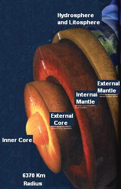
The Inner of the Earth

Standard Model inside of the Earth


California Earthquake Incidence Map: To day | Paper ( Matthew Gerstenberger)


The Geophysics Team
x.95


Faltan

Vamos en el Gúgolplex

 para el millón


CMA - Centro Meteorológico Ambiental

PRONÓSTICO NEURONAL DE CONTAMINACIÓN ATMOSFÉRICA

Santiago ahora | AccuWeather
El Mundo ahora | SSEC
Registro de Propiedad Intelectual Nº 148.917 © GeoEnterprises - Todos los derechos reservados
Se permite la reproducción parcial con tal que se cite la fuente: "TGT- www.geofisica.cl"


Home


Hosted by www.Geocities.ws

1