
Yucatan
 .
.
ARCHAEOLOGY
 Oxkintok
The archaeological site is located 70 kilometres south of Merida. According to research the city was inhabited from the Superior Preclassic period (300 B.C.-300 A.C.) up to the Postclassic period (1250-1500 D.C.). The hieroglyphic inscriptions found contain dates, some of which are the oldest known in Yucatan. The dates indicate that the city had its major importance between the years 475 A.C. and 859 A.C.
Oxkintok is a Mayan word composed by the words ox (three), kin (Sun) and tok (flint or stone), that means "Three stone Suns". It is composed of four architectural sets called Ah-Canul, May, Tzat Tun Tzat and Dzib. Oxkintok's most known and ancient building is the Tzat Tun Tzat, which is a construction with three levels; inside there's a series of narrow and long rooms which communicate through small gates and narrow stairs.
Season: All Year

 Ek Balam
It is located 180 Km. from Merida, 64 Km. from Chichén Itzá and 24 Km. from Valladolid. With majestic, impressive and unique architecture, its name means "Black Jaguar". Its origin has been dated around 400 BC, in the preclassic period and its splendor occurs between 600 and 900 AC in the postclassic.
The ornamentation is very peculiar and the buildings fronts have a great variety of features, of carved stone or shaped polychromed stucco, or a mixture of both elements. The archaeologists deduce that it was an important city, by the great dimensions of its buildings and because it was protected by three walls; two of them surround the central part, where the most important constructions are. The walls have five entrances from which start an equal number of sak be'obb, or roads in Maya. The roads, that according to evidence were made of stone and stucco, depart towards all four cardinal points. In the south side, there are two entrances and two sak be'obb (sacbés).
The Ek Balam's central part has two squares. In the larger one there are the twin pyramids and a habitational building. There is also the Acropolis, which is the largest structure. The Acropolis is formed by several levels of constructions and terraces.
Season: All Year
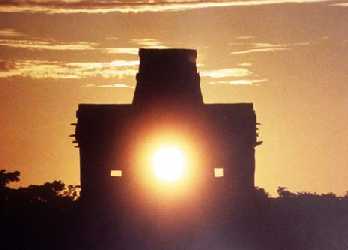
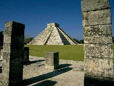 Chichén Itzá
The city of Chichen Itza is the best preserved and impressive of the Maya civilization remains that are left. It has the best records of the spiritual, domestic and agricultural way of life of the Mayan ancestors. Its culture has influenced many areas of architecture, art, and astronomy, both in the ancient and the modern world.
Around the year 550 A. C. the Mayans settled in Chichen Itza (Mayan word that means "the mouth of the well"). Chichen Itza is located in a sylvan area of limestone through which rainwater filters, and is stopped by harder rock underneath. The water channels formed are known as "cenotes". The cenotes were the oasis of the community, plenty of water provided the necessary life support. Chichen Itza, as other major Maya cities, was a political, ceremonial and spiritual center rather than a commercial area.
It is known that Chichen Itza was abandoned in the 10th century. This it is a recurrent evidence, since all the Mayan cities were left around this period; nevertheless, the abandon has not been fully explained. The Mayans returned around the year 1000 A.C. This is evidenced by two architectural styles found in Chichen Itza: the traditional Mayan architecture, and more recently the influence of the Toltecs' architecture. The Toltecs were warriors that invaded Chichen Itza around the year 800 A.C. and introduced human sacrifice as part of their rituals.
One of the structures that is believed to be constructed before 800 A.C. is The Castle, a building that sheds light on the impressive Mayan astronomical system. The Castle is in fact a solar calendar, with 91 steps to each side and one more for the altar. Every day the shades fall on a different step. With The Castle, the Mayans knew exactly when to start their crops.
The Snail is another astronomically oriented structure. It's a giant domed observatory where many rituals and celebrations took place. The dome has many windows completely pigmented. The stars can be seen through different windows in specific dates. This structure is one of the pinnacles of the Mayan architecture. Constructing a dome of stone is a complex work, but to create it with windows in precise points, takes an enormous quantity of work and knowledge. The Snail, simultaneously shows us that the Mayans were experts in astronomy and engineering. This is one the Chichen Itza's major attractions nowadays.
The Chichen Itza's Ball Game is the biggest in Mexico. The fields were very similar to today's football courts. High stone hoops were placed on the walls at both ends. The Mayans played a complex and difficult game with a hard, solid rubber ball. Both teams had to maintain the ball off the floor without using their hands, and scored passing the ball through the hoop. After the Toltec invasion the ball game takes another twist, in which the losing team was frequently sacrificed.
Season: All Year
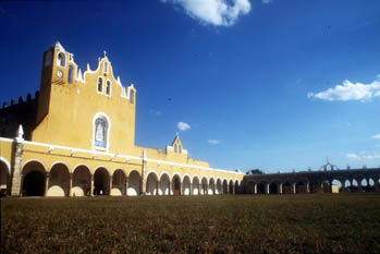
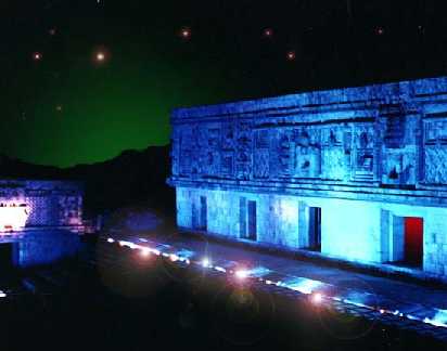
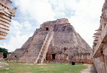 Uxmal
Uxmal
Its name means "three times constructed", it is 78 Km. Southwest of Merida, immediately after the mountain chain Puuc that crosses northeast to southwest. According to researchers the first inhabitants of Uxmal arrived around 800 B.C. It is possible that many of the current buildings belong to this period, but excavations haven't verified it.
Agriculture was one of the main activities of the inhabitants in Uxmal, this is verified by the construction of "chultunes" (cisterns) founded there, and that was used to accumulate the rainwater; with this activity the city grew to become a powerful political center in the zone.
During the Classic Early Period (200-600 D.C.) Uxmal acquired typical attributes of the region and other sites; it shared the style called Puuc, as well as an architecture known as typical Chenes of Campeche's north zone.
 In the Postlassic Period Uxmal developed its own architectural style known as Late Puuc, this style is distinctive by including serpent motives.
By the year 700 to 1000 D.C. Uxmal already dominated economically and politically a vast territory, had implemented a complex agricultural system and developed trade with other regions, mostly with obsidian and basalt. It was in this period that the Xiu came to this area, this group brought new ideological elements that were reflected in the architecture and decoration of sculptures. A distinctive element was the cult of Kukulcan or Quetzalcoatl.
Season: All Year
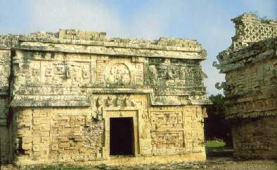
 Dzibilchaltun
"Where there are writings on flat stones" is undoubtedly one of the most amazing urban centers of the mysterious Maya civilization.
Located 22 Kms from Merida, this archaeological site has an incredible quantity of stone buildings, like "The Palace", "The Temple of the Pedestal" and "The House of the seven dolls", where a beautiful spectacle can be observed, when during the Autumn and Spring equinox the sun projects the mask of the Rain God, Chaac, one of the most important deities of the rich Mayan cosmogony.
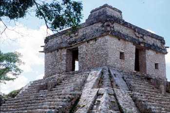
You won't resist the temptation of taking a dive into the beautiful X'Lacah cenote, surrounded by a surprising variety of plants and animals, many of them endemic of this particular spot.
Season: All Year
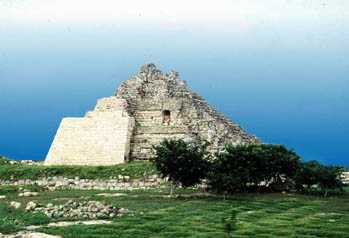
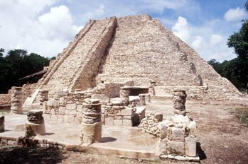 Mayapan
Mayapan is 47 kms southeast of Mérida. It was the most important center of Maya civilization previous to the arrival of the Spanish conquerors (1250-1450 D.C.). Mayapan covers an area of 4 km˛ and like every Maya city, has a central plaza where the main buildings are located.
This city was built, like Chichen Itza, during a period of wars among the several decadent Maya provinces. A characteristic of this is that the central nucleus is surrounded by a wall, clear indication of the unstable situation in the area.
It is estimated that the population in the city was about 12,000 people. According to legend, Mayapan was founded by Kukulcan (Quetzalcoatl), who ruled for a time and then the main leaders formed a joint government. Native chronicles tell us that Mayapan formed a political alliance with Uxmal and Chichen Itza, known as the Mayapan league. The most notorious construction is the Castle of Kukulcan, identical to the Castle of Chichen Itza.
Season: All Year
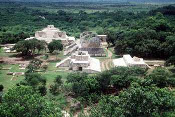
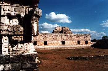
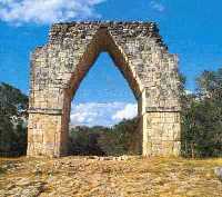
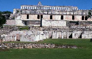 Kabah
Kabah
It has been translated as "Lord of the strong or powerful hand". The city was always in the Mayan's conscience, even after the Spanish conquest and it is mentioned in the ancient texts of the Chilam Balam of Chumayel; thus it is assumed that its importance was similar to Uxmal's.
It is distinguished by signs of a long occupation, its strategic location and the quality of the carved stones that embellish and give meaning to their constructions. It has a small town with a central temple that marks the entrance to the city. From this place, the building concentration increases until great Arch of entry to the monumental area.
Three big architectural sets conform Kabah's urban nucleus. The Palace square shows the architectural development of the Puuc between the VII and X centuries a.C.; from the Early Puuc style in the Temple of the Sun, through an intermediate style in the voluminous Teocalli, up to the Palace, prototype of the architecture of the Puuc. But it is the palatial sanctuary of the Codz Pop ("coiled mat") that characterises Kabah, an example of the baroque style in the Mayan architecture. The west front has more than 250 Chac's large masks and is covered with stones forming mosaics from the starting of the walls up to the cornice; its recently explored and partially restored Eastern front, with decorated walls and wide steles, seven warriors or heroes, and with a few finely sculpted jambs, where the latest date of the peninsula (987 a.C.) stands out; and the scenes of a ritual dance and the apprehension and death of an important personage.
 The epoch of development, height and decline of the Puuc has been determined to be during the Late Classic Period (600 to 900 a. C.). Though there is no doubt that sites of the magnitude of Kabah, Uxmal, Sayil and Labná had precedents that go back to the Early Classic (250a 600d. C.). In general terms there are some architectural elements that correspond to nearby regions; for example, from The Petén, the "cresteras" at the head of the temples and decoration shaped with stucco on the fronts; and from the region of the Chenes, the fronts that represent a zoomorphic deity. These elements were integrated to the Puuc style, but they do not lose their individuality. The formal elements and the outline of the cities with the mentioned style were not random works, every element and building forms a part of the detailed plan and related to the cosmos and to man. Due to Kabah's magnitude, much yet to be researched. Due to the available information it is known that the extension of this city was comparable to Uxmal.
Season: All Year
COLONIAL
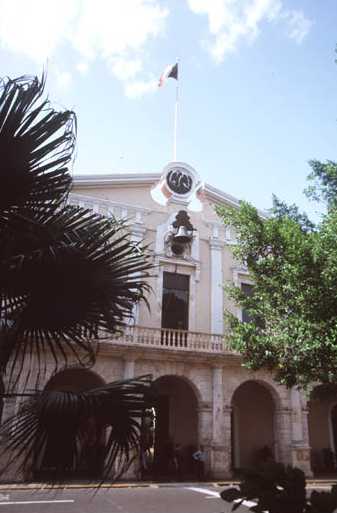 Merida
Yucatan State's Capital; economic and cultural center of Mexico's South-east, is prime touristic destination. "The white city" of the 20th century, to which poets and troubadours have sung, was founded on January 6, 1542 over the indigenous remains of the city of Ichcaanzihó, also called T'hó. The name was granted to it for "the fine buildings of worked limestone and well carved moldings like those the Romans built in Merida, Spain".
The sacred stones of the indigenous temples served to build the houses and buildings of the conquerors, as well as the temples of the new Christian faith. In the mosaic that the diverse regions of the country form, Merida's are known by their hospitality and the pride they feel for their Maya and Spanish inheritance.
Merida had a concentric urban development during the colony. The indigenous towns slowly were converted into city neighbourhoods because of the Spanish population growth and they reproduced in their towns the characteristics of the central nucleus, always with the church and the central square as governing axis.
 During the XVII and XVIII centuries, the city marked its limits with seven arches built by the Military Engineer Manuel Jorge de Zezera, the urban overflow surrounded them and today only three remain as witnesses of what the city used to be: San Juan, Dragons and the Bridge.
In Merida, the ancient and the new join with originality, respect to tradition and modern urban development. Walking its streets and sites of interest - museums, parks, markets, malls, boutiques, crafts and typical clothes markets - offers a wide range of possibilities to the traveller. At night Merida is fascinating with outdoor coffee shops, fine restaurants, serenades, concerts, discoteques, night clubs or charriot rides. On Sundays you can walk in search of crafts, a good piece of traditional art or some folkloric dance show. At any time or day the Yucatecan food is a pleasing experience.
Season: All Year
 Valladolid
To the east of Yucatan, Valladolid was scenario for rebellions and fights between conquerors and natives. The submission of the Mayans of the East of Yucatan was assigned to a conqueror's nephew also called Francisco de Montejo. He established his camp around a lagoon the natives called Chouac-Há, which meant Long Water. This site would be the center of operations to submit the cupules and to take their capital, Zacihual, which means "white Sparrow-hawk ", a raptor bird that symbolised the warlike qualities of this community.
 Zaci; located to 50 Km. inland, to the south of Chauac indian province, was an important political and religious center where the nobility of the Cupul lineage resided. Conquering Conil's Cupules and Sotuta's Cocomes was the most difficult and oppressive task for the soldiers. Once Zaci was defeated, its wide zone of influence fell. On May 23, 1543 Montejo the nephew, founded in Chouac-há the villa which he called Valladolid, in honor of the Castilian city of the same name.
Valladolid is a few minutes from the Chichen Itza archaeological zone and one hour and a half from Cancun's beaches. It has the San Bernardino convent, majestic in its dimensions and sober in his Franciscan style. Its principal altarpiece was worked in wood and covered in gold, with sculptures and motives that give it an unmistakable baroque air. The Virgin of Guadalupe in the convent is about years old.
San Gervasio's church and its towers, still have the cannons used to recover the city in 1848, after it fell under rebellious Indians who started the War of Castes. Nearby is the cenote Zaci, deep sweet water well which served in the past to provide the city with water, and is now a restaurant and natural pond.
A visit to Valladolid cannot be complete without trying its fine regional cuisine.
Season: All Year
 Izamal
Founded by the itzaes, owes its name to Itzamna or Zamna "Dew from the Sky", mythical character of singular wisdom assumed as instructor and teacher of the Mayan people. This colonial city is known as "the city of the three cultures", since it combines features of its pre-Hispanic heritage, the colonial period and current times. For centuries it was a place of pilgrimage for the Maya and in colonial times a Christian sanctuary.
Izamal was once an enormous Mayan ceremonial center. It is believed that it is older than Chichen Itza and Uxmal. For 5 years the INAH (National Institute of Anthropology and History) has been making excavations and restorations in the site. They have found and catalogued about 80 pre-Hispanic structures inside the trace of the city, one of the most important is the pyramid Kinich Kak Moo, which would be the third greatest pre-Hispanic structure in volume in Mexico. The convent of San Antonio was raised over the ruins of an old ceremonial center and dedicated to the Virgin of the Conception. This convent has the biggest closed vestibule of Mexico, close in dimensions to that of San Paul in Rome. It has 75 arches that form an impressive hallway of 7,806 square meters.
It is a beautiful and pleasant city to take a chariot ride and to enjoy for a day or two. Named the city of the hills, meaning the covered pyramids, Izamal is in the geographical center of the peninsula. Its history, from its foundation to the present, is tied to a strong religious tradition.
Almost all the buildings of the city are painted yellow, which gives it a unique flavour. The enormous convent with its 75 arches is not the exception. For the tourist who seeks something different while in Yucatan and would like to take an exciting trip, we suggest that a visit to Izamal.
Season: All Year
ECOTOURISM & ADVENTURE
 Calcehtoc Grottoes
The Calcehtok caverns, also known as "Aktun Spukil", are considered among the biggest in the Yucatan Peninsula along with the Lol-Tun caverns and have very complex tunnel systems. The meaning of this word derives from the mayan "cal" (neck), "ceh" (deer) and "tok" (flint). It got this name in 1875 when a sculpted stone deer was discovered in an open well in the area.
The main access to the entrance is a 3 Km. pavimented road, the descent is made on an iron ladder. Once into the main chamber, four different tours can be made, the most interesting has 2 Km. of galleries; natural formations called "the crocodrile", "the horse", "the tongue", "the mommy", and "the divine face" can be seen in this largest gallerie called cave #4.
Abundance of pre-hispanic materials is found in all the cavern; intact vessels, and unexplored chambers are still waiting to be discovered to add more knowledge of the Mayan culture. Arqueologists have found bones of deer and from other animals, ceramics, quartzite hammers, arrowheads, human graves, etc. Some vessels that were used by the mayans to collect the filtered water of the ceilings are completely petrified. In the first two chambers you can see the stockades that the mayan rebels used during the "Guerra de Castas" rebelion.
It is not advisible to get into these caverns alone, you should have a guide with you. Also, a big complex of more than 30 caves exists in the sourroundigs, with hidden wells all over the area, so caution is recommended.
Season: All Year
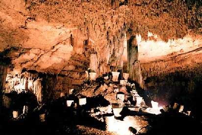
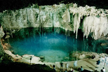
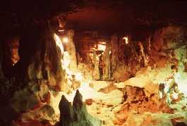
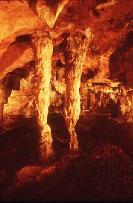 Grutas y zona arqueológica de Lol-Tun
Su nombre proviene de los vocablos mayas "Lol": flor y "Tun": piedra, o "Lugar de las flores de piedra". Son de las más grandes conocidas dentro del sistema de cavernas de Yucatan. Se encuentran situadas a siete kilómetros al Suroeste de Oxkutzcab y a 24 Km. al Noreste de las Ruinas de Labná.
Las grutas se han acondicionado para realizar con seguridad un recorrido de aproximadamente 1 Km de longitud en su interior. En estas Grutas se han encontrado evidencias de asentamientos humanos de hace 400 a 7,000 ańos, principalmente restos de cerámica. El recorrido inicia en la entrada de Nahkab (colmena), donde se localiza el famoso bajorrelieve conocido como "El Guerrero de Loltún", el cual representa efectivamente un guerrero ricamente ataviado de unos 2.5 m. de altura, que parece estar emergiendo de la gruta. Por su estilo parece pertenecer a la época preclásica y puede representar al Dios Chaac, guardián de las grutas.
 Luego se pasa a la galería principal en donde se encuentra las primeras formaciones calcáreas, sugestivas figuras de estalactitas y estalagmitas plateadas y doradas que la imaginación popular ha venido bautizando con nombres como la "Catedral", impresionante bóveda de 30 m. De altura aproximadamente, "la galería del gran cańón", "la mazorca de maíz", el "cuarto de estalactitas", etc. En esta galería hay esculpida una cabeza humana de rasgos olmecas con penacho y otros adornos. Además, se encontraron ahí vasijas y otros utensilios, así como restos de moluscos y conchas. En una de sus cavidades, conocida como "Huechil" (del maya "Huech": armadillo), se realizaron excavaciones donde en sus niveles más bajos se hallaron restos de fauna extinta: huesos de mamut, de bisonte, de un felino, etc.; que indican un período de clima frío y de vegetación distinta a la actual característica de un ambiente cálido y húmedo. En "la galería de los haltunes" se hallan depósitos de agua natural.
 Otro atractivo de mucho interés son las pinturas rupestres, en un muro se aprecian manos en negativo, en otro se localizan pinturas rupestres más elaboradas que representan rostros, animales y grecas escalonadas, otras cámaras tienen decoraciones e inscripciones. Cerca de ellas hay un abismo de unos 20 m. de profundidad, donde rodaron rocas enormes, probablemente a causa del hundimiento del techo de cámaras más profundas. En la Sala de las Inscripciones, de impresionante belleza, existe un tramo de más de 100 m. adornado de estalactitas y con gran cantidad de pinturas de manos y de personas, así como petroglifos tallados en forma de flores, los que dan su nombre a las grutas. Finalmente, está la llamada Loltún de Pendiente Pronunciada, galería por la que se sale a la superficie a través de una escalera labrada en la piedra. En esta área se pueden ver las barricadas construidas por los rebeldes Mayas que se refugiaron aquí durante la Guerra de Castas.
Season: All Year
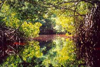
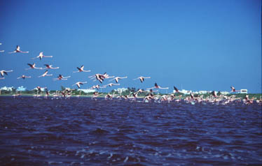
 Celestún
A sólo 90 Kms. de la ciudad de Mérida, se ubica el Parque Nacional de Celestún, un escaparate de ejemplares de flora y fauna endémicos.
Su nombre significa "Piedra Pintada". En Celestún se pueden encontrar extensas playas plagadas de cocoteros. Visita obligada son los manglares de la ría, su importancia deriva de ser un espacio de alimentación y descanso de un elevado número de aves migratorias, así como por ser uno de los dos sitios en México donde anida, se alimenta y reproduce el flamenco rosa. También es un sitio clave para algunas tortugas marinas y el cocodrilo de pantano. Parte de la aventura son los paseos por el manglar. Las lanchas navegan a través de túneles naturales formados por el follaje de los árboles, arrullados por el trino de las aves.
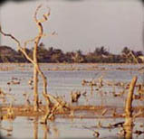
 El "ojo Baldiosera" es la mayor concentración de agua dulce dentro del manglar. Cuenta con pequeńos muelles y pasajes por donde los visitantes pueden tener acceso al lugar. Las cristalinas, refrescantes aguas invitan al viajero a darse un chapuzón. Al otro lado de la ría se ubica el bosque petrificado de Tampetén, un espacio digno de la creatividad de un artista plástico: los árboles secos dan forma a imágenes surrealistas, caprichosas, donde el tiempo parece haberse detenido.
Temporada: Todo el Ańo
 La Reserva de la Biosfera Ría Lagartos
Esta es una de las zonas de manglares y petenes más grande e importante de la Península de Yucatan. En la región hay escasos asentamientos humanos, lo que favorece la concentración de especies animales.
Conscientes de la importancia de mantener en buen estado el ecosistema, y para preservar el hábitat de los animales, las autoridades de la reserva desarrollan un programa de trabajo -mediante brigadas de colaboradores- con el propósito de desazolvar los flujos de agua dulce que regulan los niveles de salinidad en el lugar.
Con los primeros trabajos de desazolve de flujos acuíferos se comenzó a intervenir un lugar conocido como "Petenmac", en las afueras de Río Lagartos y a tan sólo unos metros del ojo de agua conocido como "Chiquilá".
Ese sitio se llama "Petenmac" porque es un petén cuyo ojo de agua dulce está rodeado por algunas palmas que los lugareńos llaman "mac" y que da frutos de apariencia similar a las peras
Temporada: Todo el Ańo
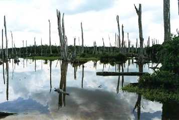
 Petenes, Pantanos y Manglares
Los humedales y petenes son ecosistemas fundamentales para el desarrollo de la vida silvestre en las zonas protegidas del mundo.
En Yucatan muchos de estos espacios se ubican dentro de las reservas y zonas protegidas de la costa, como El Palmar, en la región de Celestún, y la Reserva de la Biosfera Ría Lagartos.
Los manglares y petenes conforman una especie de archipiélago verde, que sobrevive en medio de las sabanas y zonas inundables, gracias al flujo natural de agua dulce que hace posible la reproducción de especies vegetales.
Los petenes son una maravilla de la naturaleza, sitios privilegiados que muy pocos tienen la oportunidad de disfrutar, ya que, por lo general, están a varios kilómetros ciénaga adentro, rodeados de zonas fangosas de baja profundidad que dificultan el desplazamiento de las embarcaciones.
La recompensa para los aventurados que incursionan por esos lares es una de las vistas más hermosas que la naturaleza haya plasmado: un ojo de agua dulce, cristalina y fresca brotando continuamente de una grieta entre la tierra, rodeado de troncos y especies de plantas endémicas. En ocasiones es posible observar a reptiles, aves y mamíferos que llegan hasta ahí para calmar la sed.
Temporada: Todo el Ańo

 Yucatan road map (480 Kb)
Sources:
Official page of Yucatan.
Acoyauh A.C.

Any adventure you wish, we can make it happen!

Information & reservations:

52 (55) 5435-5060