| Lake Fausse Point State Park New Iberia, La |
 |
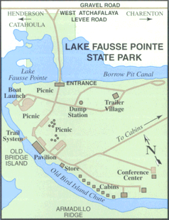
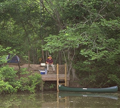
| Directions 5400 Levee Road, St Martinville, La 70582 Take La 96 (note: this exit is in Broussard, off of Hwy 90 / I49) to La 679, then to La 3083. Turn RIGHT onto Levee Road for 8 miles (this portion of trip takes about 40-50 minutes).. To lafayette from Shreveport: Take I49 South to Lafayette (4 hrs) Ruston to Lafayette Hwy 167 to I49 (Pineville/Alexandria) Take I49 to Lafayette (3hrs 45 min). Lafayette to Broussard: I49 turns into Hwy 90 East/I49 expansion. Stay on Hwy90 for 25 minutes/ about 10 miles. You are in broussard. When you see the overpass (Albertons on right) take exit just before it. Turn Left. Go under overpass. Take Left onto hwy 96. See above. Pictures New Cabin Trail Park Map primative site |
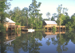
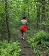
| Park Description Nice park, many camp sites. Ones on the water share a dock on the water. Fun for kids and parents alike. Note: this is south Louisiana. The summers are hot and do have mosquitos (unoffical state bird). Also, if you don't like the weather stick around for a few minutes... this also goes if the weather is nice (and the converse). Trail Description: there are 3 trails, of which connect. A trail (loop) is about .8 miles. Upon exit of this relatively flat (and fast) portion of the trail, take left (now on B part of trail). (note: left = back to trail head). B trail (about 2 miles) passes by an overlook over a swampy section, note: very shallow, hence little boat traffic. The trail y's. I usually go right, however, you can go either way. right will meet up with the left trail at the start of Trail C (about 5 miles). This is relatively uneventful, and can be fast or muddy. Watch out for the low hanging trees. Left is more swampy (now has covered bridge over sections, relatively new. Note: this is because when it rains, the lake literally engulfs this portion of the trail. Snakes and sometimes even gators are prevelant. Also note: you are not usually in danger unless you provoke these animals. If you see one, turn around. Ride away quietly and quickly ). Toward the end of the swampy portion there is an uphill which is about the most you will see on this trail. It is a part of a drainage project from many years back. This is a fun, tight singletrack section. Down the hill and toward the start of Trail C. Trail C (for years after Hurricane Andrew was uncleared and closed, reopened for a year, then another hurricane. I believe it is open as of now). This trail meanders through more swampy area, and is pretty scenic. Some wooden bridges over wet areas. I believe this trail will loop back near the new cabins (note: old trail went here, but was more technical if I remember correctly). This loops back and ends up on the road to the new cabins. |
 |