Rodington Old Windmill
|
When when Robert was born, the
miller George Hampton was the probably biggest employer in Rodington and the
surrounding area, next to the Rector of Rodington who lived just up the road.
The Rector employed a cook, a nurse, a housemaid, a nursemaid, and a general servant, and they all lived in a big house with the Rector and his family. The house recently sold for £875,000. |
|||
|
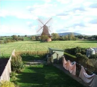
The Old Windmill - Rodington |
|
However, George Hampton's Windmill was open to the wind in a good position in a field behind the church, and he ground a great deal of flour. Local farmers brought their crops to the Old Windmill and it was a thriving industry. The majority of flour was stowed in his warehouse ready for shipping, while the rest to be sold locally. The roads from the warehouse lead straight to Rodington Canal Wharf for distribution of his flour to Shrewsbury and Newport, and beyond. So, as Robert grew up, the Old Windmill was an important feature in the community, and Robert would have eaten many pies and bread from the flour of George Hampton.
|
|
|
|
|||
|
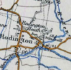
This old map shows the complex web of lanes,
roads, the Canal and the River Roden that existed in and around Rodington Village.
The Shropshire Union Canal Shrewsbury branch helped to serve the Rodington area and other hamlets like Chapel Crossroads. These routes were all used for transporting the flour from the Old Mill, and other goods such as coal, bricks and stone were also transported. |
|
||
|
Rodington Old Map |
|||
|
|
|||
|
The Old Windmill today |
|
Sadly, the Old Windmill no longer exists. The red brick base exists to
this day.
I just thought it would to help show a windmill, to capture the moment in time, as it would have been seen by
Robert Madeley. Here is a view of the Old Windmill base from Gilbert Mount off Church Road as it appeared in 2009.
|
|
|
|
|||
|
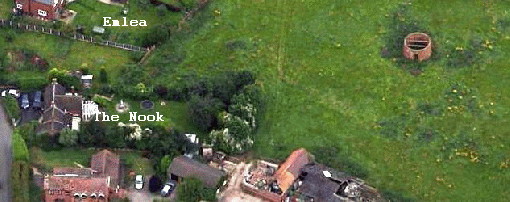
An Aerial View of the Old Mill
|
|
The aerial shot shows the size of the Old Windmill compared with 'The Nook' residence on Church Road next to the pond. The pond field can be seen near the road between the houses 'Emlea' and 'The Nook' on Church Road, and overgrown access to the Old Windmill should be found there.
|
|
|
Further along the road 'The Villa' is an early 19th century red brick house, which is protected by Grade II Listing. The Old Windmill is early 19th century to early 20th century - 1800 AD to 1913 AD. It does not have listed protection. |
|||
|
|
|||