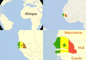

Located between 12.8 and 16.41 degrees North Latitude and 11.21 and 17.32 West Latitude,Senegal sits at the westernmost edge of the African continent,bordered by Guinea and Guinea-Bissau to the south, Mali to the east, Mauritania to the north and the North Atlantic Ocean to the west. The independent nation of The Gambia is almost entirely engulfed by Senegal's south-western region,Casamance, separating northern Senegal from its southern region. The entire country covers 196192 square kilometers and is slightly smaller than Great Britain or South Dakota. Senegal consists of 10 regions or major administrative zones with 30 departments and 99 districts.
Senegal's climate is pleasantly tropical,with average daily temperatures range from 18�C (65�F) and 31�C (87�F)and displays two major climatic season: the rainy season lasting from July to September, with rainfall ranging from 300mm (12in)to 600mm (24in) annually; and the dry season going from December to April marqued by hot and dry harmattan winds off the Sahara. Senegal enjoys year round sunlight exposure as well as a moderate to severe drought and desertification.
One of the most biologically diverse country in the Sahel, the semi-arid region south of the Sahara desert, Senegal hosts over 550 animal species as well considerable colonies of birds migrating through the Parc National aux Oiseaux du Djoudj, one of the world's major bird reserves, north of St-Louis. The best time to travel in Senegal is between November and March, when it's cool and dry. From February to April, the waters are at their clearest for great scuba-diving and from November to April is the birds migratory season as well as the hunting season.