A realistic perspective on historic
rainfall and stream flows for SW Western Australia against a background
of Goverment water policy
Residents of Perth know that for five years now following the dry year
of 2001 and worsened low dam levels, the Government and
Water Authorities (all Govt) have been making statements to the
effect that "climate change" is reducing our rainfall and hence our
stream flows to dams, we have
heard Premier Gallop complaining about "a 30 year drought", hardly a
week goes by that we do not
hear about "our drying climate".
WA policy makers should know that rainfall, like all climate
statistics, is naturally variable and varies on all time scales.
WA policymakers make claims that the decline in SW WA rain in the
1970's is robbing us of our water supply, when a more
rational approach would admit that the high rainfall years
from WWI to the 1970's may in fact have been
abnormally HIGH, and the last 35 years rain regime we are now in might
be normal. The decline is only about 10% if you take
the 1975-2006 average over the 1900-1974 average.
An analysis of the facts about our water supply and rainfall trends
actually shows that Govts prior to 2001 did not take account of Perth's
growth and plan a water supply for NORMAL dryer
years that must occur. 2001 in Perth was only the 15th dryest
year.
Dam levels had been falling for years before 2001 click for my
graphic of Composite trends in Perth water resources.
Many
communities on the planet would "give their right arms" for this
SW WA rainfall and would be harvesting and using it wisely and not
panicking
into madly expensive seawater desalination.
WA Govt water policy post 2001 evolved to the ridiculous state
that we now enjoy, for a number of reasons, including.
- The Govt could blame a larger force, "climate change" for
our
water problems instead of accepting that there had been
inadequate planning.
- The Govt knew that years of neglecting catchment management
had
been a significant factor in reduced dam inflows but also knew
that the greens were trenchantly opposed to touching the bush and the
memory of the role of the Liberals for Forests movement in tipping out
the previous Coalition Govt was very fresh in the then Premiers
mind. In fact the Govt is involved in a 12 year TRIAL of catchment management
on
the tiny Wungong
catchment which is only 3.8% of total catchment area. Could they
do
any less.
- The Govt found that it could constantly repeat the mantras of
"our
drying climate", the media could be relied upon to go along, there is a
ready coalition of water "experts" who find more expensive water
appealing and so it came to pass that seawater desalination became part
of the water supply mix for this region that enjoys excellent
rainfall.
- It is puzzling that Govt refuses to cut the Gnangara pines thus
accepting the ongoing loss of Billions of dollars worth of
potentially pumpable groundwater each year, a figure far in excess of
any valuation that could be constructed for the pines.
- Recently we have seen a huge waste of taxpayer monies over
years as WaterCorp tested the vast Yarragadee SW groundwater. Now
we find that the Enviromental Depts. of the Govt under green and SW WA
NIMBY pressure have killed that proposal in favour of a near $Billion
second desalination plant near Bunbury .
- Who
can hope to understand Govt policy which emerges from a Byzantine
tangle of factions, party mates, secret lobbyists
scurrying hither and thither, policies built on myths, all
at
a time when Govt coffers are so overflowing with money from the
resources boom that a team of High School students could run the
State better.
Anyway, back to Premier Carpenters statements in Hansard on the "Errors
in IPCC climate science" Blog.
Mr A.J. CARPENTER (WA Premier): “..It
has stopped raining in the south
west of Western Australia. The rain no longer falls from the sky in
sufficient quantities to fill the dams to fill the pipes to fill the
cups for people to drink…”
Here is what the BoM says about rainfall trends for SW WA 1900-2006

At this point it is interesting to look at the graphic of
catchment yields from Perth catchments showing the stunning decline in
yield percentage 1980-2006 from around 4.5 to 6% in the mid
1990's to now under 3%. With a catchment area of 3500
square kms and lets say an average of 800mm of catchment rain May to
Oct that could run into streams, that means ~2800 GL of rain falls.
An extra 2.5% could easily be converted to dam
inflows
after catchment management,
which would provide an extra 70GL
of water per
year on average. Worth about $1.2 billion in saved
investment, taking the cost
of the Binningup seawater desalination plant as a guide.

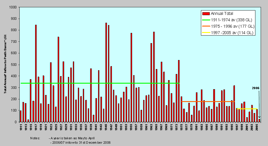
Finally, a quick look at a Govt graphic from WaterCorp that has
played a role in convincing all and sundry, including the Federal Govt,
that climate change and "our drying climate" has taken away Perth
water. This graph constructed mainly from data from only
the tiny Wungong catchment (3.8% of total area) is exposed as
hugely misleading by the graphic above showing stream flows have
fallen away sharply with a slope that can not be explained by
rain trends which are much flatter.
Nothing the Govt says on water or rainfall can be trusted without the
most searching examination.
Graphic headed "Yearly Streamflow for Major Surface Water Sources"
found at http://www.watercorporation.com.au/D/dams_rain.cfm
I imagine a boardroom in Paris, around the table are some salespeople
for Degremont the desalination company. Someone says, (in
French of course) "I have just come back from Perth in Western
Australia, they are indeed a strange people, despite having forested
water supply catchments of 3500 squ kms, dams all paid for years
ago and
rainfall in excess of a metre a year they are buying our water
factories."
End of page for now.