|
|
Geographical
Information
System
(GIS) |
|
|
|
|
|
What is
GIS? |
|
|
Geography is information about the earth's surface and the
objects found on it, as well as a framework for organizing
knowledge. Therefore GIS is a technology that manages,
analyzes, and disseminates geographic knowledge.
GIS links
location to information and layers that information to give
you a better understanding of how it all interrelates. You
choose what layers to combine based on your purpose. |
|
|
So how do we get these geographical images? |
|
|
There are two ways of getting them, depending on your
requirement. If accuracy is not your prime concern, then the
satellite images is your first choice. Even the satellite
images have different resolution accuracies. For example, the
LANDSET satellite images provide you with a 15-metre
resolution, whereas the SPOT5 can provide you with better
accuracy, at 2-metre resolution. Whereas the normal satellite
images only provide two-dimensional graphics, certain
satellite images like the SRTM DEM can provide you with
three-dimensional data. |
|
|
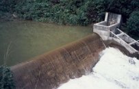
Certain users require a more accurate
data. For example, an engineering hydrologist who wishes to
design a flood mitigation scheme for a certain river basin
requires accurate data on the catchments area. For such users,
I recommend retrieving the data using LiDAR, where a
laser-based sensor is placed in an aircraft to fly over the
catchment area, where the land topography and anything on it
can be captured in detail. |
|
|
.
|
|
|
|
|
|
|
|
|
|
|
 |
|
 |
|
|
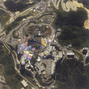
Satellite Image of
Genting Highlands |
|
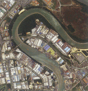
Satellite Image of
Port Klang |
| |
|
|
The photos above show the satellite image of the
Genting Highlands and Port Klang in MALAYSIA.
With the availability of such images, the management
of the Genting Highland Group, for example, is able
to plan and manage their assets effectively. From the
image, the location of the streets and the buildings can
be traced and the overall security and traffic
management system can be planned and implemented
effectively. From the computer monitor itself, one
can, for example, know the best route to take to get to
a particular building. |
|
|
. |
|
|
GIS can also
provide the geographical details of changes that had
occurred at a certain area, like the changes that
occurred in Acheh in Indonesia after the
tsunami that occurred on 26 December 04.
|
|
|
. |
|
|
|
|
|
|
 |
|
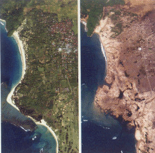
The photo on the left shows the image of Acheh
taken a few months before the tsunami incidence
hit the town.
The photo on the right shows Acheh 3 days after
the tsunami incidence. |
|
Satellite Images of Acheh before and after the
Tsunami |
|
| |
| |
|
|
|
|
|
|
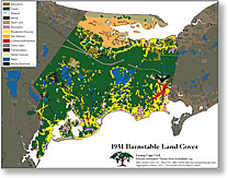
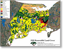
The images on the right are from a poster titled
"Losing Cape Cod," which is distributed by the Woods
Hole Research Center in Woods Hole, Massachusetts. The
poster shows the severe change in land use on Cape Cod
since 1951. The image on the top shows the town of
Barnstable in 1951 and the image at the bottom shows
Barnstable in 1999. |
|
 |
|
|
|
|
|
|
|
To know the changes in land use is very
important for some Government bodies. For example, owners of
dams may want to know how the activities at the
catchment area of the dam can affect the performance and
capacity of the reservoir. Too much logging activities in
the catchment, for example, can increase sedimentation
and reduce the water volume in the reservoir. These
logging and other activities in the catchment can be traced
from the satellite images or by LiDAR and by the use
of GIS technology, the activities can be monitored and
controlled. |
|
 |
|
|
|
|
|
|
|
GIS is also a useful tool for engineering
design and can check for errors on the ground survey.
From my own previous experience,a certain
project faced discrepancies in level between the original
ground levels and those shown on the construction drawings. It
was later found that the discrepancies were due to errors
committed by the land surveyor who carried out the work before
the engineering design started. As a result, the design of the
road had to be revised to suit the actual ground level. The
revision in design cost the Client substantial amount of
money, which could be avoided if GIS technology was
utilised.
|
|
|
|
|
|
|
|
|
|
|
|
|
|
|
For further enquiries or information, please
write to [email protected] |
|
|
or fill and send the mail
form |
|
|
|
|
|
Address: 8C, Jalan Mesra 1, Taman
Mesra, Shah Alam, Selangor Darul Ehsan,
MALAYSIA. |
|
|
|
|
|
|
|
|
|
|
|
Tel: +603-5519
1855 |
|
Fax : +603-5519
2866 |
|
Mobile: +6013-2020
998 |
| |
|
|
|
| |
|