| Earthquakes around the world |
| Earthquakes are the result of forces causing release of stored energy in rocks below the earth's surface.Tectonic forces build up energy slowly in layers 25 miles within earth along the fault lines. Shearing movements along the faults in the crust of the earth make rapid changes in this region. The stored energy is released suddenly, a sudden rupture takes place. The region oscillates.This sudden motion causes shock waves (seismic waves) to radiate from their point of origin called the focus. The oscillations grow suddenly and rapidly, but earth can not sustain the oscillations for long. After a few minutes they subside. The seismic waves that travel through the earthproduce ground movements which we call an earthquake. The point on the Earth's surface directly above the focus is called the epicenter of the earthquake. These waves travel very rapidly through the earth's surface, can reach 500 kms in a minute. Depth of epicenter is recoded. Destruction and damage depends on depth, shallower epicenter means more devastations on surface. For detection and measurement of earthquakes they are classified into two types, primary (P) and secondary (S). Magnitude of earthquake is related to the amplitude of seismic energy waves. They are recorded on instruments called seismographs. Seismographs record a amplitude trace that shows the ground oscillations beneath the instrument. Sensitive seismographs can detect strong earthquakes from very far places. The time, location, and magnitude of an earthquake can be determined from the data recorded by seismograph stations. |
| Earthquakes mostly happen along the boundaries between tectonic plates. About 70% of the earthquakes in the world happen around the Pacific rim, going from New Zealand to New Guinea, past the Philippines, Taiwan, Japan, Kamchatka, Alaska, the western United States, Mexico, Central America, and western South America. This is also called the "ring of fire." Many of the rest happen in an east-west band across southern Europe, the Middle East, and northern India/southern China. A recent earthquake Location 3.30�N, 95.78�E Depth 10 km (6 miles) |
| The largest earthquake ever recorded in the United States would probably be the 1964 Alaska earthquake, which measured in with a moment magnitude of 9.2 |
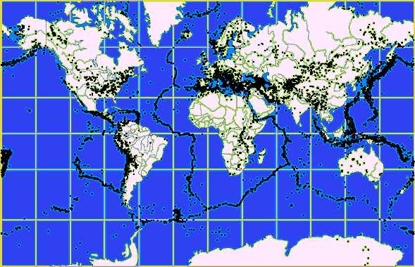 |
| World map showing the fault lines |
| All the seven contintental plates were connected millions of years ago in the form a super-continent called Pangea. With progress of time, they moved apart slowly and continously. This movement is called continental drift. |
| mouse over to start a quake |
| A strong earthquake occurred at 00:58:50 (UTC) on Friday, December 26, 2004. The magnitude 9 event has been located near North West Sumatra. The huge earthquake caused Large tsunamis in south east Asian countries. Tsunamis have killed at least 300,000 people in south-eastern Asia. |
| On same day, same time in 2003, a large earthquake killed 30,000 people in Iran |
| recent earthquake |
| cause of earthquake |
| earthquake picture |
| earthquake information |