 |
 |
 |
Easy isn't it ?(when you know how !!)
DO NOT ALLOW ANY PERSON TO SIT ON THE NOSE OR FRONT OF THE BOAT WHEN MOTORING AROUND ON THE MAIN ENGINE.
Have sufficient Lifejackets/Bouyancy
aids for ALL
the people on board
Keep your hands out of the
water !!!
Rather than "tough it out"
through a Storm, find a safe anchorage. Being wet and miserable, or cold
and dry (and of course probably hungry) is better than being drowned or
injured.
Make sure your Bilge pumps are working AND that you have the bucket in the boat. (your battery may go flat.)
Keep ALL of the following in your boat, whenever out on a large dam or lake :-
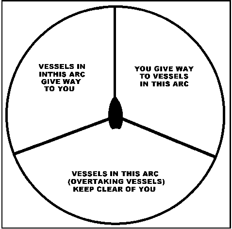
Lights on a boat
RED is LEFT SIDE (PORT)(All
the shorter words ?) andGREEN
is RIGHT SIDE (STARBOARD)(All the longer words ?)
The rear light is a clear white
light and you should not(??)
be able to see the nav lights on the side if looking from the rear.
Wind Drift
When driving along and the wind
is blowing from the side, watch out for drifting off course with the help
of the wind and the waves. The boat compass says the boat is pointing in
the right direction, but in the meantime you are being pushed sideways
off course.
Bouys and Markers
As of this time there are very
fews bouys, spars or markers on the water, so these have not been dealt
with. If you do see some then by all means come back to us and we will
include some information on what they mean.
Go Top
Compass
You must make sure that the bearing is correct
on your compass as it is affected by all the metal in the boat and by the
electric's in the boat, so make sure that the boat has been "COMPASS
SWUNG" whilst the engine is running and has
the normal equipment in it.
(You cannot just buy it from
the shop and fit it. Nothing is that easy)
Charts/Mapping
Try to have a Chart (or Map) of the water
you are fishing and take note of the Magnetic Variances if you are
using a Compass, as there will be an error from this "Magnetic
Deviation". Most Charts have the Magnetic
Variance marked on them. (I can hear them
now, "what is the difference between a Chart and a Map ?
- Answer - A
Chart is used for lakes, dams and seas, and normally has soundings or DEPTH
Contours on it. A Map is used for those bits above the water)
Get your maps laminated, so you can carry
them in the boat without getting damaged by water.
GPS Units
If you are lucky enough to own such an item,
the time spent finding out how they work is well spent. Make sure you know
how to plot waypoints and your Home base.
They are very accurate and are not subject
to things such as Magnetic Variances etc..
If you are going to use the GPS to navigate
to a new spot or area then make sure that you have your map marked with
the accurate degrees and minutes of Lattitude and longitude (and of course
you must know how to read the map). They are very accurate and they can
take you home.
Help for those without compass
or GPS.
Firstly - GET A MAP/CHART so you have some
idea of what you are facing on your excursion into the "wild blue yonder".
Secondly - Try to go with someone who already
knows the area you intend to go to.
Thirdly - Try to remember the points and landfalls
that you pass, so you know how to get back.
Remember it looks different from the other
way, so keep looking behind you on the way there, and it will be more familiar
on the way back.
Fourthly - Keep looking around, so you can
recognise places again for the future, and ask questions of those that
may know the area.
If you are going somewhere new, use a map to give you basic directions, using points, islands or land areas you might be able to recognise, both going there and coming back. TAKE THE MAP IN THE BOAT.
REMEMBER which way the wind was blowing, as this may be a guide to help you find where you want to go
If you get lost and end up in
the dark, look for land based lights to guide you to where you may be wanting
to go, or to a safer (?) place.
Drive SLOWLY and CAREFULLY as
you do not know what might be sticking up out of the water in the dark.
If you see another set of Navigational
Lights from another boat remember that RED
is LEFT SIDE (PORT)(All the shorter words ?) andGREEN
is RIGHT SIDE (STARBOARD)(All the longer words ?)
Go Top