


Maps
We have provided 2 maps to help you locate our community. The first is a larger map of Pinellas County and the second is a more detailed map of our location within eastern Pinellas County.
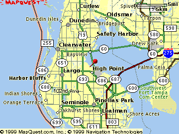
Location in Pinellas County
This map shows Overlook in relation to the entire Pinellas County. We are located in the eastern part of mid-Pinellas, near the Tampa Bay. The location is convenient to the Howard Frankland, Courtney Campbell and Bayside bridges, and is just minutes from the St. Pete/Clearwater Airport.
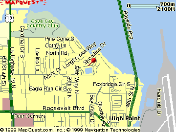
Detailed Location
This map shows a detailed location of Overlook. We are surrounded by the Bayside Bridge, Roosevelt Blvd., and US 19.
To reach us from north US 19, take the Whitney Road exit east; drive approximately 2 miles (you will pass a fire house). Turn left (north) on Shoreline Drive (you will see a lake on your left) and take the first right to the Community.
To reach us from south US 19, take the Roosevelt/East Bay Drive exit east. Drive approximately 2 miles to the corner of 58th Street North. Turn north (left) on 58th street; drive 1/4 mile. Turn east (right) on Whitney Road and drive 1/4 mile. Turn left (north) on Shoreline Drive (you will see a lake on your left) and take the first right to the Community.
To reach us from Tampa, take the Howard Franklin Bridge to Clearwater. Exit at the Clearwater/Largo exit, which leads into Roosevelt Road. Continue on Roosevelt road (veering right) and continue past the St. Pete/Clearwater Airport. Drive 2 miles past the airport, and turn north (right) on 58th Street North. Drive 1/4 mile on 58th Street, then turn east (right) on Whitney Road and drive 1/4 mile. Turn left (north) on Shoreline Drive (you will see a lake on your left) and take the first right to the Community.
This site developed and maintained by |
Joanne Kuzma ([email protected]) |