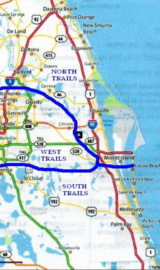
South trails are those that are South of Hwy 520 in Brevard County, Florida. All hikes to the South will meet at The Sams Club parking lot on Hwy 192 in Melbourne near I-95. Hikes start at 8:30, click on schedule link at top right for next Wednesday Hike destination or click on trail name for more information on that trail.
DIRECTIONS TO PRAIRIE LAKES LOOP TRAIL
From Sams Club parking lot on I-95 and hwy 192, drive 20 miles west on 192 to Holopaw. Turn south on hwy 441 about twenty miles to Kenansville. Turn right on hwy 523 (Canoe Creek Road) about ten miles to the entrance of Prairie Lakes Wildlife Management Area. Drive in about two miles to a parking area beside a creek (there is a six dollar fee per car to enter the area.) One trail begins on the west side of the bridge on either side of the road and is a loop of five and a half miles length. Another trail forms a loop on the East side of the bridge and is about six miles in length. These are great trails for wildlife viewing, birding and butterflying. Fishing is also good.
for more info, goto http://www.outintheboonies.com/prairie_lakes/
GPS for meetingplace is N28 4.712', W80 41.815', for the entrance is N27 55.662' W81 7.494' the trailhead is N27 54.428' W81 8.006'
DIRECTIONS TO THE SUNSET RANCH TRAIL
From Sams Club parking lot on I-95 and hwy 192, drive 20 miles west on 192 to Holopaw. Turn south on hwy 441 about twenty miles to Kenansville. Turn right on hwy 523 (Canoe Creek Road) about eight miles to the Sunset Ranch Parking area. The trail is about two miles in length traversing a mix of forest and wetland. There are boardwalks and an observation deck overlooking the wetland.
GPS for meetingplace is N28 4.712', W80 41.815', for the trailhead is N27 54.244', W81 5.886'
DIRECTIONS TO THREE LAKES TRAIL
From Sams Club parking lot on I-95 and hwy 192, drive west on 192 to Holopaw. Turn south on hwy 441 about thirteen and a half miles to the Three Lakes entrance road (Williams Road.) Drive on Williams Road about three miles to the Florida Trail crossing, This, the North bound section runs through pine forest about four miles to Hwy 414. The South bound section is on Williams Road until it passes under the Florida Turnpike, there it enters pine forest and open prairie for about two and a half miles until it intersects Hwy 523.
for more info, goto http://www.outintheboonies.com/three_lakes/
GPS for meetingplace is N28 4.712', W80 41.815', for the trailhead is N27 57.699' W81 0.269'
DIRECTIONS TO SPLIT OAK TRAIL
From Sams parking lot on hwy 192 and I-95 take 192 west through Holopaw to Hwy 15. Take 15 north about nine miles to Clapp Sims Duda Road. Take Clapp Sims Duda road about a mile and a half to the Split Oak trail parking area on the right side of the road. The trails starts at the kiosk and vary from less than a mile to about four miles depending on trails you take. See map on kiosk. Some trails are sandy and some can be wet. Scenery varies from ordinary to excellent depending on trail.
for more info, goto http://www.outintheboonies.com/split_oak/
GPS for meetingplace is N28 4.712', W80 41.815', for the trailhead is N28 21.110' W81 14.123' (DUDA ROAD)
DIRECTIONS TO BULL CREEK CEMETERY TRAIL
From Sams Club parking lot on Hwy 192 in Melbourne, proceed west on 192 through the town of Deer Park. About two and a half miles past the Hwy 419 intersection in Deer Park, locate the gated levee road on the south side of the Highway. We park there and walk past the gate and down to the trail marker at the bottom of the levee on the right. Walk about a mile to the campground then follow the blazes across Crabgrass Creek to a road to the cemetery. the total distance is about five miles. There are several other trails in Bull Creek some of which are excellent, some ordinary. Most are wet in the rainy season but are worth it if you are prepared.
for more info, goto http://www.outintheboonies.com/bull_creek/
GPS for meetingplace is N28 4.712', W80 41.815', for the trailhead is N28 7.015' W80 55.948'
DIRECTIONS TO BULL CREEK MAIN ENTRANCE
From Sams Club parking lot on Hwy 192 in Melbourne, proceed west on 192 through the town of Deer Park. About seven and a half miles past the Hwy 419 intersection in Deer Park, find Crabgrass Creek Road. Take Crabgrass Creek Road to its end at the Bull Creek WMA entrance, get a map at the checkstation and ask about which trails are wet or dry. Ecosystems vary from very wet to very dry but are all excellent.
for more info, goto http://www.outintheboonies.com/bull_creek/
GPS for meetingplace is N28 4.712', W80 41.815', for the trailhead is N28 7.870' W81 0.612'
DIRECTIONS TO LAKE ARBUCKLE TRAIL
From Sams Discount Club, on hwy 192 near I-95, take I-95 south about forty miles to hwy 60 (Yeehaw Junction exit.) Take hwy 60 about 45 miles (through Yeehaw Junction) to Hwy 630. Take 630 south 9.2 miles to Blue Jordan Forest Road and turn left. Proceed 1.7 miles to Lake Reedy Blvd. and turn left at the traffic light. Drive a short way to Lake Arbuckle Road and turn left. Proceed one and a half miles to Rucks Dairy Road and turn right, drive 0.8 miles and park in lot on left just across a small bridge. One end of the trail starts here. The other end of the trail is accessed by driving north, from the first trailhead , on School Bus Road about three miles (find a fenced parking lot at 2.8 miles and proceed another tenth of a mile or so.) There will be a small parking lot with a blue blazed trail crossing the road. Trail is mostly dry and very scenic.
for more info, goto http://www.outintheboonies.com/arbuckle_tract/
GPS for meetingplace is N28 4.712', W80 41.815', for the trailhead is N27 42.480' W81 26.758'
DIRECTIONS TO THE MALABAR SCRUB TRAILS
From Sams Discount Club, on hwy 192 near I-95, take I-95 south to hwy 514 (Malabar Road.) Take Malabar Road East three miles to the Malabar Fire Station, turn left into a divided road a few hundred feet to the entrance to the Malabar Community Park. Park in the park parking area and find the kiosk at the gate at the end of the road you came in on. the trails are described there and range from very short to about three miles in length. Trails are mostly in thinned pine upland.
for more info, goto http://www.eelbrevard.com/eel/ep_recreation.php?pnl=1_9
GPS for meetingplace is N28 4.712', W80 41.815', for the trailhead is N28 0.075' W80 34.952'
DIRECTIONS TO THE THREE FORKS MARSH TRAILS
From Sams Discount Club, on hwy 192 near I-95, take I-95 south to hwy 514 (Malabar Road.) Take Malabar Road West nine miles (the last two are unpaved) to the Three Forks Marsh Conservation Area. There are many miles of levees that are open to the public but are one way in and one way back, no loops. These are good cool day hikes as they are totally open and without shade. Great bicycling!
for more info, goto http://sjr.state.fl.us/recreationguide/s07/index.html
GPS for meetingplace is N28 4.712', W80 41.815', for the trailhead is N27 58.937' W80 45.290'
DIRECTIONS TO THE MICCO SCRUB TRAIL
From Sams Discount Club, on hwy 192 near I-95, take I-95 south to hwy 514 (Malabar Road.) Take Malabar Road a short distance to hwy 507 (Babcock Street.) Take Babcock Street south about 8.5 miles and turn left on Micco Road. Take Micco Road 0.6 miles and the parking area is on the left side of the road . The trail is about four miles long and is mostly in scrub palmetto.
for more info, goto http://www.eelbrevard.com/eel/ep_recreation.php?pnl=1_11
GPS for meetingplace is N28 4.712', W80 41.815', for the trailhead is N27 52.456' W80 36.849'
DIRECTIONS TO ST. SEBASTIAN RIVER BUFFER TRAIL
From Sams Discount Club, on hwy 192 near I-95, take I-95 south to hwy 514 (Malabar Road.) Take Malabar Road a short distance to hwy 507 (Babcock Street.) Take Babcock Street south about twelve miles to the St. Sebastian Buffer Preserve entrance (on the north side of the C-54 Canal.) Stop at the Ranger Office about two miles inside the preserve, there are several trails of varying lengths and varying ecosystems so get a map from the ranger.
for more info, goto http://www.floridastateparks.org/stsebastian/
GPS for meetingplace is N28 4.712', W80 41.815', for the trailhead is N27 49.457' W80 36.433'
DIRECTIONS TO SOUTH BEACHES TRAILS
From Sams Discount Club in Melbourne at hwy 192 near I-95, take 192 East through Melbourne to hwy A1A. Turn right on A1A and drive south 6.1 miles. Look for a kiosk on the West side of the road at the Coconut Point trailhead across the Highway from the Ponce de Leon Park. The trail is 0.75 miles long and terminates on Hwy A1A at the 6.3 mile mark. The second trail is 10.2 miles from the 192 - A1A junction, on the West side of the road and is named Maritime Hammock Trail. It is a two mile loop ending as before on A1A at the 10.4 mile point.The Barrier Island trail starts across the highway from Bonsteel Park at the fourteen mile point from 192. It is a 0.5 mile loop to the river around and back to A1A. The palmetto scrub visible from the highway quickly gives way to spectacular tropical forest on all three trails. Good everythinging!
for more info, goto http://www.eelbrevard.com/eel/ep_recreation.php
GPS for meetingplace is N28 4.712', W80 41.815', for the trailhead is N27 57.216' W80 30.070'
DIRECTIONS TO FORT DRUM TRAIL
From Sams Discount Club in Melbourne at hwy 192 near I-95, take I-95 south about forty miles to Hwy 60, take 60 west about twelve miles to the Fort Drum wildlife management area on the south side of the road. Turn south into the property about two or three miles to the trailhead. The trail is about a three mile loop.
for more info, goto http://www.outintheboonies.com/Fort_Drum/
GPS for meetingplace is N28 4.712', W80 41.815', for the trailhead is N27 38.481' W80 45.986'
DIRECTIONS TO THE DISNEY WILDERNESS TRAILS
From Sams Club parking lot on I-95 and hwy 192, drive west on 192 to Kissimmee. Turn left onto Hwy 17-92 (Main Street). Continue through downtown until you meet John Young Parkway (continuation of Hwy 17-92), continue over the overpass about three miles to Pleasant Hill Road. Turn left on Pleasant Hill Road and drive about 8 miles to Old Pleasant Hill Road (there is a Nature Conservancy sign on the right side of Pleasant Hill Road). Drive about a quarter mile and locate a large gate on the left side of Old Pleasant Hill Road marked Nature Conservancy Disney Wilderness Preserve. Drive through the gate and continue to the visitor center and register and pay a two dollar per person fee. There are two trails, a 2.5 mile trail and a five mile trail, get map at visitor center. Both are mostly on roads through palmetto scrub.
for more info, goto http://www.nature.org/wherewework/northamerica/states/florida/preserves/art5523.html
GPS for meetingplace is N28 4.712', W80 41.815', for the trailhead is N28 7.761' W81 25.842'
DIRECTIONS TO TRIPLE N RANCH TRAILS
From Sams Club parking lot on I-95 and hwy 192, drive west on 192 through the town of Deer Park. In about 12 miles find the Triple N Ranch sign and entrance road. Park just off Hwy 192 in the campground parking lot. There are seven and a half miles of developed trail and lots of roads to explore. Trails are mostly thinned pine land but there are lots of forested areas and some seasonally wet cypress domes.
for more info, goto http://www.outintheboonies.com/Triple_N_Ranch/
GPS for meetingplace is N28 4.712', W80 41.815', for the trailhead is N28 7.886' W81 1.249'
DIRECTIONS TO FELLSMERE GRADE TRAILS
From Sams Discount Club, on hwy 192 near I-95, take I-95 south to hwy 514 (Malabar Road.) Take Malabar Road a short distance to hwy 507 (Babcock Street.) Take Babcock Street south about twelve miles to the St. Sebastian Buffer Preserve entrance (on the north side of the C-54 canal). Turn right, after crossing the canal, on Fellsmere Grade Road and drive to the end of the road. There is a parking lot at the end with access to many levees in the Goodwin Waterfowl Management Area.
for more info, goto http://myfwc.com/Viewing/sites/site-ec08.html
GPS for meetingplace is N28 4.712', W80 41.815', for the trailhead is N27 49.625' W80 42.512'