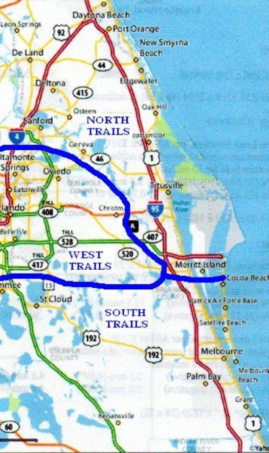
West trails are those that are accessed from Hwy 520 West of I-95. All hikes to the West meet at Lone Cabbage Fish Camp parking lot (James Bourbeau Park) on Hwy 520 by the St. Johns River. Hikes start at 8:30 AM, click schedule link for next Wednesday Hike destination or click on the trail name for more information on that trail.
DIRECTIONS TO SOLDIER CREEK TRAIL
From Lone Cabbage Fish Camp at Hwy 520 and St. Johns River, take hwy 520 West all the way to the junction with Hwy 50. Continue west on 50 through Bithlo to Hwy 419. Turn right on 419, proceed through Oviedo (turn right at traffic light, marked Central Ave; look for Town House Restaurant on corner, there is a bypass now cutting diagonally to hwy 419 which can be used) Continue on 419 (another right turn at Winter Springs) to Soldier Creek baseball fields. The trail heads South along Soldier Creek, crossing the Cross Seminole Multiuse Trail, and ends at Hwy 17-92. After backtracking the above trail, drive to the Spring Hammock trails, at the far side of the field on the right side of the highway, turn right on Osprey Trail. Park in lot on right side of road. The trail starts there and is about four miles long. There are several trails here some of which are wet and some dry. Scenery is outstanding on all of them. There are a couple of boardwalks which pass some magnificent Cypress trees, one ends over Lake Jessup. Usually we proceed to Big Tree Park for lunch after this trail. To get there, continue west on 419 to the intersection with hwy 17 - 92. Go south on 17 - 92 to the traffic light and turn right on General Hutchinson Road, go about two miles to Big Tree Park on the left.
for more info, goto http://www.seminolecountyfl.gov/leisure/natland/hammock.asp
GPS for meetingplace is N28 22.151', W80 52.259', for the trailhead is N28 43.168', W81 18.563'
BEGIN ECON STATE FOREST TRAILS
DIRECTIONS TO CHULUOTA SPUR TRAIL
From Lone Cabbage Fish Camp at Hwy 520 and St. Johns River, take hwy 520 West all the way to the junction with Hwy 50. Continue west on 50through Bithlo to Hwy 419. Turn right on 419 through Chuluota to Snowhill Road. Take Snowhill Road 0.4 miles to Jacobs Tr., turn left on Jacobs Tr. and park at the end of the road by the Florida Trail trailhead sign. The trail is along the Flagler Railroad bed which joins the other Econ State Forest trails at the Econ river bridge and is about one mile long.
GPS for meetingplace is N28 22.151', W80 52.259', for the trailhead is N28 38.944', W81 7.822'
DIRECTIONS TO THE JONES EAST BIKE TRAIL TRAILHEAD
From Lone Cabbage Fish Camp at Hwy 520 and St. Johns River, take hwy 520 West all the way to the junction with Hwy 50. Continue west on 50 through Bithlo to Hwy 419. Turn right on 419 through Chuluota and turn right on Snowhill Road . Continue on Snowhill road about three miles to the trailhead on the left side of the road. There are some biking trails and a white blazed hiking trail which leads to the Econ River suspension bridge in about a mile.
GPS for meetingplace is N28 22.151', W80 52.259', for the trailhead is N28 41.141' W81 6.951'
DIRECTIONS TO THE ECON STATE FOREST WHITE SPUR TRAIL
From Lone Cabbage Fish Camp at Hwy 520 and St. Johns River, take hwy 520 West all the way to the junction with Hwy 50. Continue west on 50 through Bithlo to Hwy 419. Turn right on 419 through Chuluota and turn right on Snowhill Road . Continue on Snowhill Road about four miles to a Large Forest Service building on the left. Drive through the building parking lot and park at the trailhead in back. The trail is about two miles long and intersects with the Flagler Railroad bed where it joins the other trails.
for more info, goto http://www.fl-dof.com/state_forests/little_big_econ.html
GPS for meetingplace is N28 22.151', W80 52.259', for the trailhead is N28 41.141' W81 6.951'
DIRECTIONS TO THE ECON STATE FOREST LOCKWOOD ST. TRAIL
From Lone Cabbage Fish Camp at Hwy 520 and St. Johns River, take hwy 520 West all the way to the junction with Hwy 50. Continue west on 50 through Bithlo to Hwy 419. Turn right on 419 through Chuluota across the Econ River. At the traffic light turn right on Lockwood Road. Proceed about a half mile to the trail crossing by the power lines. The trail is about three miles and ends at the Barr Street trailhead. See description below.
for more info, goto http://www.outintheboonies.com/Little_Big_Econ/
GPS for meetingplace is N28 22.151', W80 52.259', for the trailhead is N28 40.012' W81 10.603'
DIRECTIONS TO ECON RIVER TRAIL BARR STREET TRAILHEAD
From Lone Cabbage Fish Camp at Hwy 520 and St. Johns River, take hwy 520 West all the way to the junction with Hwy 50. Continue west on 50 through Bithlo to Hwy 419. Turn right on 419 through Chuluota across the Econ River. At the traffic light turn right on Lockwood Road. Continue to the end of Lockwood Road and turn right on hwy 426 about 0.75 miles to Barr Street. Park in the Parking area on the right side of the road. The trail is about five miles total along the river to the new bridge and back. The orange blazed trail also continues North back to Lockwood Road, about a two mile one way hike. Scenery is outstanding on both trails. There is a two dollar per person fee to enter the trail.
for more info, goto http://www.outintheboonies.com/Little_Big_Econ/
GPS for meetingplace is N28 22.151', W80 52.259', for the trailhead is N28 41.229' W81 9.567'
DIRECTIONS TO THE BLACK HAMMOCK WILDERNESS TRAIL
From Lone Cabbage Fish Camp at Hwy 520 and St. Johns River, take hwy 520 West all the way to the junction with Hwy 50. Continue west on 50 through Bithlo to Hwy 419. Turn right on 419 through Chuluota across the Econ River. At the traffic light turn right on Lockwood Road. Continue to the end of Lockwood Road and turn right on hwy 426 about 0.75 miles to Barr Street. Park in the Parking area on the right side of the road. Cross Hwy 426 at the marked trail entrance. Follow the path 0.4 miles to a dirt road and another 0.5 miles to the trailhead on Howard Avenue. There is a parking area on Howard Avenue but it is hard to find and often closed. The trail itself starts there and loops 4.5 mile round trip. The blue blazed trail is part pine upland with several wetland areas, there is a long boardwalk across the wettest area. Total length from Barr Street and back is 6.3 miles. There is a two dollar per person fee to enter the trail.
for more info, goto http://www.seminolecountyfl.gov/leisure/natland/bhammock.asp
GPS for meetingplace is N28 22.151', W80 52.259', for the trailhead is N28 41.229' W81.9.567'
DIRECTIONS TO THE GENEVA WILDERNESS TRAILS
From Lone Cabbage Fish Camp at Hwy 520 and St. Johns River, take hwy 520 West all the way to the junction with Hwy 50. Continue west on 50 through Bithlo to Hwy 419. Turn right on 419 through Chuluota across the Econ River. At the traffic light turn right on Lockwood Road. Continue to the end of Lockwood Road and turn right on hwy 426 about four miles to the Geneva Wilderness Area trailhead on the right. There are several trails here of varying lengths some of which connect to the Econ State Forest trails. See brochure at the trailhead.
for more info, goto http://www.seminolecountyfl.gov/leisure/natland/geneva.asp
GPS for meetingplace is N28 22.151', W80 52.259', for the trailhead is N28 42.577' W81 7.438'
END ECON STATE FOREST TRAILS
DIRECTIONS TO ORLANDO WETLANDS PARK TRAIL
From Lone Cabbage Fish Camp at Hwy 520 and St. Johns River, take hwy 520 West past the Beeline, about a mile and a half past the Beeline turn right on Taylor Creek Road (look for sign for Tosohatchee Wildlife Management Area.) Take Taylor Creek Road all the way to Hwy 50, turn left on 50 to Hwy 420. Take 420 (Fort Christmas Road) about two miles until the road turns sharply west. Turn right onto Wheeler Road (look for Orlando Wetlands Park sign,) before the turn. Drive about a mile on Wheeler road to the Orlando Wetlands Park parking lot. There are several variations on the trail we can do, all being about five miles in length. World class wildlife, wildflowers and birding. You can access the Seminole Ranch trails by continuing East on Wheeler Road or North across Lake Searcy.
for more info, goto http://www.outintheboonies.com/Orlando_Wetlands/
GPS for meetingplace is N28 22.151', W80 52.259', for the trailhead is N28 34.185' W80 59.796'
DIRECTIONS TO THE TOSOHATCHEE SOUTH TRAIL
From Lone Cabbage Fish Camp at Hwy 520 and St. Johns River, take hwy 520 West about two miles to a parking area on the south side of the highway Park there at the trailhead inside the unlocked gate. Total distance is about four miles. There is a white blazed loop trail with an intersecting trail at the halfway point which continues to Taylor Creek but is sometimes wet. Lots of wildlife in here.
for more info, goto http://www.outintheboonies.com/tosohatchee/
GPS for meetingplace is N28 22.151', W80 52.259', for the trailhead is N28 22.449' W80 54.270'
DIRECTIONS TO THE TOSOHATCHEE LOOP TRAIL
From Lone Cabbage Fish Camp at Hwy 520 and St. Johns River, take hwy 520 West past the Beeline, about a mile and a half past the Beeline turn right on Taylor Creek Road (look for sign for Tosohatchee Wildlife Management Area.) Take Taylor Creek Road about three miles to the Tosohatchee preserve entrance. There is a three dollar per vehicle entrance fee. There are several hikes we can do from there most being five miles or so in length. Get a map at the entrance kiosk, in wet weather, check in the visitor center to find which trails are wet. The power line trails are always dry and have excellent wildlife viewing opportunities.
for more info, goto http://www.outintheboonies.com/tosohatchee/
GPS for meetingplace is N28 22.151', W80 52.259', for the trailhead is N28,29.897' W80,59.872'
DIRECTIONS TO THE SEMINOLE RANCH LOOP TRAIL
From Lone Cabbage Fish Camp at Hwy 520 and St. Johns River, take hwy 520 West past the Beeline, about a mile and a half past the Beeline turn right on Taylor Creek Road (look for sign for Tosohatchee Wildlife Management Area.) Take Taylor Creek Road all the way to Hwy 50. Turn right on 50 and proceed to the Christmas RV Park entrance, turn left on the park entrance road. Stay on the road a short way until you come to an open gate. Park outside the gate and walk in on the road until you see the trailhead on the right. The trail is about two and a half miles to Wheeler Road (Orlando Wetlands Park) on the orange trail or about three miles on the white trail. Lots of wildlife but cattle are pastured seasonally. Excellent scenery, old oak trees and pretty creeks.
for more info, goto http://www.outintheboonies.com/seminole_ranch/
GPS for meetingplace is N28 22.151', W80 52.259', for the trailhead is N28 32.290' W80 59.281'
DIRECTIONS TO CHULUOTA WILDERNESS TRAIL
From Lone Cabbage Fish Camp at Hwy 520 and St. Johns River, take hwy 520 West all the way to the junction with Hwy 50. Continue west on 50 through Bithlo to Hwy 419. Turn right on 419 and proceed about five miles toward Chuluota, at Mills Lake road turn right and proceed to Curryville road. About one mile down Curryville road, find the trailhead on the right side of the road. The trailhead is somewhat hidden so look closely. There are two main loops of about two and a half miles each plus a few side trails to explore. Trails are sandy in dry weather with many wet areas.
GPS for meetingplace is N28 22.151', W80 52.259', for the trailhead is N28 37.556' W81 5.701' (approximately)
DIRECTIONS TO SABAL POINT SANCTUARY
From Lone Cabbage Fish Camp at Hwy 520 and St. Johns River, take hwy 520 West all the way to the junction with Hwy 50. Continue west on 50 through Bithlo to Hwy 419. Turn right on 419, proceed through Oviedo (turn right at traffic light, marked Central Ave; look for Town House Restaurant on corner) Continue on 419 which is also Hwy 434. Stay on 434 until it crosses I-4 and turn right on Wekiva Springs Road in a mile or so. Stay on Wekiva Springs Road for about a mile and turn right on Sabal Palm Drive. Continue for about two miles to Wilderness Drive, turn right on Wilderness Drive and park at the end of the road by the Sabal Point Sanctuary gate. The trail is about 3.5 miles long along tram roads. Lots of wildflowers and wildlife in season.
for more info, goto http://www.audubonofflorida.org/specialplaces_sanctuaries_sabalpoint.html
GPS for meetingplace is N28 22.151', W80 52.259', for the trailhead is N28 42.673' W81 24.609'
DIRECTIONS TO HAL SCOTT REGIONAL PRESERVE
From Lone Cabbage Fish Camp at Hwy 520 and St. Johns River, take Hwy 520 West about fifteen miles to Maxim Parkway into the Wedgefield Subdivision. Turn left on Bancroft St. then right on Meredith St. and finally left onto Dallas St. The entrance is on the right accessing several trails through a variety of habitats. These trails tend to be wet so dress accordingly.
for more info, goto http://www.outintheboonies.com/hal_scott/
GPS for meetingplace is N28 22.151', W80 52.259', for the trailhead is N28 29.172' W81 5.740'
DIRECTIONS TO THE ECON RIVER WILDERNESS TRAIL
From Lone Cabbage at Hwy 520 and St. Johns River, take Hwy 520 West all the way to Hwy 434 (Alafaya Trail). Take 434 North about three miles to McColloch Rd. Take McColloch East about a mile and a half to Old Lockwood Rd. Take Old Lockwood a few yards North to the entrance for the area. The trail is about three miles max depending on which side trails you take. Trail is through mostly thinned pine upland but there are some low areas near the Econ River. Good wildflowers and wildlife but horrendous traffic to get there.
GPS for meetingplace is N28 22.151', W80 52.259', for the trailhead is N28 36.738' W81 10.459'