Math Concepts
Personal Information
School Information
Reference Materials
Information for Students
Problem of the Week
Chaparral & New Mexico
Math Tutorial
Marvelous Math Links
Odds & Ends
Games and Gadgets
Fraction Calculator
Weekly Skills Quiz
Famous Matematicians
Student of the Month
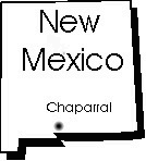

The community of Chaparral, NM lies just north of the New Mexico-Texas state line from the north-east side of El Paso, TX and is about 35 miles south-south-east of Las Cruces, New Mexico. Located in this community of about 10,000 are an elementary, and intermediate, and a middle school. High school students are taken by bus about 12 miles west to the Mesilla valley of the Rio Grande River where they attend Gadsden High School. Chaparral is in the Tularosa Basin just south of White Sands National Monument and the White Sands Missile Range, it enjoys a warm, sunny climate with a long growing season and in spite of the fact we live in a desert, the Mesilla Valley (the Spanish ll is pronounced much like 'ya') with its extensive irrigation system, provides the region with rich and productive farmland. Major crops in the area include cans, onions, cotton, dairy farms and the ever-popular CHILI! The state's official question is "Red or Green?" in reference to CHILI! both the red and green chilis have their aficionados! In New Mexico Chili is spelled with an 'i' when referring to the plant, while the 'e' ending generally refers to the 'Texas' concoction made with meat, beans and chili powder. We of course would prefer an enchilada, tostado or burrito served up with a generous helping of frijoles-refried beans. Most New Mexicans prefer their enchiladas flat, in a stack, rather than rolled, and with a nice fried egg on top!
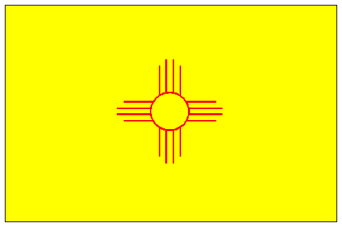
It should be noted that "New Mexico" is neither New nor is it Mexico. The earliest European settlements in North America, following centuries of native habitation, are found here and it was admitted to the United States as the 47th state on 6 January 1912. Santa Fe is the oldest continuously occupied capital city in North America having been founded before the pilgrims landed at Plymouth Rock. The name arises from the legend of 'the seven cities of Cibola', the seven cites of gold. Spain had acquired great wealth in Mexico and the hope was that the area to the north would in turn become a 'New' Mexico. Although both gold and silver have been found and mined in the region it has never produced great wealth from such activities.
The Mesilla Valley of the Rio Grande also marks the route of 'El Camino Real', the Spanish Royal Road to Santa Fe and the route of the Conquistadores. Just north of Las Cruces is found the 'Jornada del Muerto', the dead man's march, a distance of 100 miles of the Camino Real with very little water, a problem on the journey north to Santa Fe.
In the Town of Mesilla, just south of Las Cruces, the courthouse where Billy the Kid was tried and sentenced to hang still stands. (During the Civil War, Mesilla also served as a confederate capitol for a short time.) About 85 miles west-north-west lies the towns of Silver City and Pi�os Altos where judge Roy Bean began his career amid a Silver Boom in the late 1800's. The area still is the sight of one of the worlds largest open pit mines. About 40 miles to the north is found Caballo and Elephant Butte lakes. An amazingly large expanse of water in the midst of the desert. Surprisingly, water recreation is very popular on a variety of lakes throughout the state. It, along with skiing in the mountain ski resorts are very popular outdoor activities. Not many are aware that there is great skiing only an hour and a half from the desert city of El Paso. Elephant Butte lake is also the sight of hot mineral springs that draw many visitors. Fifty miles to the northwest lies the "City of the Rocks" An amazing formation of rocks virtually unique in the world. Thirty-five miles to the north east is White Sands National Monument which is just south of a recent lava flow known as Valley of the Fires. The white, black contrast between the two is distinctive from space and used as a landmark by astronauts. Lying 90 miles to the northwest is Lincoln, NM, site of the Lincoln County War and the jail Billy the Kid broke out of where you can still see the bullet holes in the courthouse left by Billy the Kid. Lew Wallace, the governor sent by Washington to clean up the aftermath of the Lincoln county war, wrote his masterpiece "Ben Hur" while in Santa Fe. (20 miles to the north of Chaparral, on what is now the White Sands Missile Range is the ranch Pat Garrett bought after the Lincoln County War. At this time he also worked as a customs agent in El Paso and investigated one of New Mexico's most notorious unsolved murder, that of Albert Fountain and his son whose bodies have never been found. Garrett's daughter wrote the New Mexico state song, "Oh, Fair New Mexico" and the family still lives in New Mexico.). Garrett and two others left his ranch, heading for Las Cruces through San Augustin pass in the Organ Mountains one day in 1903. Just outside Las Cruces while relieving himself, Garrett was shot in the back and killed. Although only two other people were present and it was fairly certain who had shot him, no one was ever prosecuted for the murder. Recently his grand daughters dedicated a state historical marker on the spot of his death near O�ate High School. Before their arrival in Tombstone, Wyatt Earp and Doc Holliday would have been found in Las Vegas, NM about a four hour drive north. It is here that Teddy Roosevelt came often, and here that he recruited the best cowboys and riders he could find for his Rough Rider Regiment.
As a result of the many outlaws who made a name for themselves in NM, there are a large number of accidental, self-inflicted gunshot wounds resulting in death listed in official records. The fact that many of these wounds were in the back did not seem to hinder the authorities verdict of accidental death. Due west is Roswell, NM site of the 'UFO crash'. To the East-Southeast is Carlsbad Caverns, one of the truly memorable caves. To the northwest is found the Grand Canyon, another memorable sight. Just over an hours drive to the west lies Columbus, NM, site of Pancho Villa's 1916 raid and the last armed invasion of the continental U.S. General Pershing's chase into Mexico provided the U.S. with valuable training in mechanized warfare prior to the entry into WWI. Parts of the original fort still stand, 6 miles north of the Mexican border, in an area that is now a park with camping and RV parking to accommodate visitors. There is also a museum. North in Albuquerque is found the largest balloon festival in the world. Each october over 700 hot air balloonists gather. If you haven't seen 700+ balloons in the air the sight simply can't be described to you.
Two hours to the northwest is the VLA, Very large Array, radio telescope. a series of 30 very large individual antennae spread out across the plains of San Augustin. This array, which is one of the world's premier radio telescopes, has opened many of the secrets of the universe and was featured in the opening scenes to the movie 2010. We also have a state highway in Alamogordo, an hours drive away, that leads to the International Space Hall of Fame. The highway number is of course 2001!
The Gadsden School District, where Chaparral is located, covers most of southern Do�a Ana County outside of Las Cruces and derives its name from the man who negotiated the Gadsden purchase following the Mexican-American war. The land was purchased to provide the U.S. with a reasonably level route for a transcontinental Railroad. Due to the later civil war, the first transcontinental railroad was built further north, through Utah. Soon afterward however, the southern route was completed in the early 1880's, and still carries freight today.
Although the Spanish town of Mesilla is older as are many of the communities in the region, Las Cruces is the area that is most rapidly growing and this year is celebrating its 150th birthday. Come and join in the fun. The city lies in the shadow of the Organ mountains, so named because their towering rock faces looked like a pipe organ to the early conquistadors. Las Cruces is also the home of New Mexico State University and the Aggies basketball team. In addition there is an excellent community college. The region is rapidly growing with new construction and opportunity everywhere. Las Cruces was recently listed in the top 10 places in the U.S. in which to retire.
The region is rich in Native along with the Spanish culture. Centuries ago the Anasasi and Mogollon peoples inhabited the region. More recently Geronimo, Victorio and other Apaches roamed the region while to the north lie several pueblo cultures, the descendants of the Anasasi, further north, the Navajo. It is the blend of these three diverse cultures Native, Spanish and Anglo, mingling slowly over centuries of time that provide the region with its unique and distinctive life style, architecture and overall culture.
In is not uncommon here to see a building made of adobe (mud) bricks, adorned with Spanish Vigas, native pottery and ristras and with a satellite dish on the roof.
We live in an interesting region, a region that is far older than the American east and remains home today to Native Americans, descendants of the conquistadors, the early American pioneers, Civil War Veterans who moved west in search of new opportunities, cowboys and ranchers, outlaws and honest citizens, later arrivals including the post WWII arrivals who plan and develop the nations future in space and nuclear science, a region that is both old and modern and includes the best of both, a land that richly deserves its state motto