

Travellers Tales
![]()
![]()
![]()
![]()
![]()
![]()
![]()
![]()
Iron Knob
Kimba
Wudinna
Minnipa
Poochera
Wirrulla
Streaky Bay
Smoky Bay
Ceduna
Denial Bay
Penong
Cactus Beach
Nundroo
Yalata
Head of Bight
Nullarbor
Border Village
Eucla
Mundrabilla
Madura
Cocklebiddy
Caiguna
Eyre
Bird Observatory
Balladonia
Norseman
|
A Journey From Iron Knob To Wirrulla via The Gawler Ranges With John Pav and Simon Clark
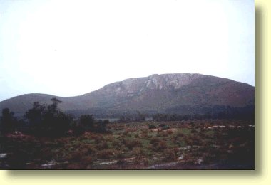
Many travellers head to Western Australia by the shortest possible route. For myself and my friend Simon this was all too easy - especially given that on many previous occasions we had aleady both travelled from Iron Knob in South Australia's Iron Triangle westwards to Wirrulla, Ceduna and points beyond via Highway One. With two female companions in the back of Rocky the Daihatsu we made the collective decision to take the "Great Northern Route" to Wirrulla travelling probably 350 to 380 kilometres of dirt roads through South Australia's vast outback. Along the way our intention was to take a detour north west from Iron Knob to pass through the sheep grazing country and National Parks that are a feature of the rugged Gawler Ranges. Our intended route was to pass Mount Nonning, and a number of sheep stations including Siam, Mount Ives, Moonaree and Yardea before finally exiting onto the Wirrulla to Kingoonya Road. From the Kingoonya Road it was an easy 40 to 50 kilometres south to Wirrulla where we could rejoin the main westward traffic flow to Western Australia. That night we camped out on the Mount Ives Road about 25 kilometeres north west of Iron Knob. We truly felt we were in the middle of the outback even though we were only 25 kilometres from the bitumen. For our two female travelling companions this was a blessedly peaceful existence after the hurly burly pace of life that they experienced in Canberra and Gundaroo in the Southern Highlands of New South Wales. In the morning we two men made breakfast, and drank some strong black before giving the girls a feed of dog biscuits. This certainly pepped them up and we proceeded down the road with Phoebe and Mingah wagging their tales side to side. Mingah's eyes were peeled on the road ahead. Phoebe however had a little more difficulty doing this as she has been totally blind for the past 8 years. Nevertheless she did try to act the part!
We expressed our surprise to Gordon that anyone could actually make a living in the harshness of this dry salt bush and Myall country. Gordon agreed with me that it was indeed difficult and that there wasn't exactly a lot money to be made. He said this with a smile and remarked that the Gawler Ranges area usually received about 7 inches of rain a year and that to date his station had received 3 inches for the first 7 months of this year. Such was our luck. We noted that it was raining and Gordon added "There's not much money to be made here but there is more money in mud than dust!" Gordon offered us some useful advice about the road conditions ahead and offered us work as station hands on Moonaree station. We gladly accepted his advice about the roads and reluctantly declined his offers of work.
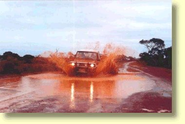
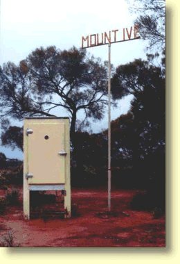
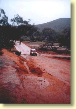
After a couple of cigarettes we bid Gordon farewell and continued our way into ever worsening road conditions. About an hour or so later we passed Mount Ive station and on Gordon's recommendation we pulled into the Mount Ive homestead and bought a half dozen beers which we intended to consume at a later date. Along the way we were continually leapfrogging the local Gawler Ranges Mail Truck which we presumed was on its weekly mail run. As the day wore on the roads turned to mud, and the mud turned into rivers - and I'm not joking when I say this. Time was now beginning to go against us, the day was beginning to wear on, and we were afraid that we might become stranded and forced to lay up in one of the local homesteads. Luck was on our side however and we pushed on past Yardea homestead. The main Wirrulla to Kingoonya road was almost within reach. All it took was a bit more persistence and a couple of extreme scares when we went into four wheel skids with the Rocky the Daihatsu's tyres pointing at 90 degrees to the edge of the flooded roadside. Within the next hour or so we began to enter Mallee country and I was amazed to think that so close to our home base in Ceduna we could travel through such magnificent countryside and actually see rivers flowing through what is normally a semi desert. Just past Yardea station we let Phoebe and Mingah out of the vehicle to stretch their legs. With that completed we then continued the next short leg of our journey to intersect with the main Wirrulla to Kingoonya Road. Within a half hour we had reached the junction of the road and headed south to Wirrulla for another 50 kilometres or so. This part of the journey was made on a well maintained dirt road. After what we had experienced however it seemed very much like a major highway. Upon reaching Wirrulla our Odyssey had come to an end and we felt well satisfied at having travelled through some of South Australia's most interesting Wilderness areas and having met Gordon who for us was something of a local hero. By the way, just for the record we didn't drink our six pack of beers until we arrived in Ceduna another hour later.
Gawler Ranges - a wet wilderness.
|
||
|
Oysters -
Whales - Fishing -
Blue Swimmer Crabs -
Quandongs -
Nullarbor
Tucker - Off The Beaten Track - Edward John Eyre -
Travellers' Tales |