chapter 8
modeling The M2S2 Tidal Flow in Great Bay
In this chapter, the Great Bay system is forced with an M2S2 tidal elevation time series at the boundary transect in Little Bay. In order to resolve the spring and neap tides in M2S2 tidal forcing, the simulation is run for 36 M2 tidal cycles, which corresponds to 447.12 hrs. The details of the boundary forcing time series is given in Chapter 6. The space-variable, depth dependent bottom friction coefficient distribution used in the M2 simulation is modified for the M2S2 simulation. The modification is done by decreasing the bottom friction coefficient values by 5% at each node. The simulation parameters are given in Table 8-1.
Table 8-1. Simulation parameters for the M2S2 forcing in Great Bay.
|
Description |
Parameters |
|
Bathymetry range |
|
|
Porous layer thickness |
h0 = 1.00m |
|
Hydraulic conductivity |
k = 0.0003162 |
|
Bottom friction coefficient |
See
Simulation C |
|
Time increment |
|
|
Time steps per tidal period |
300 |
|
Tidal periodicity |
T = 12.42 hrs (M2) |
|
Length of simulation |
|
|
Numerical implicity |
|
|
Number of nonlinear iterations |
4 |
8.1 Results for the M2S2 Forcing without Eelgrass
The simulation results are examined in two parts: the Spring tide and the Neap tide. For this purpose, two windows are chosen on the M2S2 tidal forcing time series. The time steps between 4800-5100 correspond to the Spring tide window and the time steps between 9300-9600 correspond to the Neap tide window.
· During the Spring tide, the water surface area of Great Bay is 19.19 km2 (9852 elements) at high water with an average depth of 2.68m and 9.64 km2 (4394 elements) at low water with an average depth of 2.08m. Thus, during the Spring tide, 50% of the surface area in Great Bay dries at low water and 31319092 m3 water is discharged during that drying process.
· During the Neap tide, the water surface area in Great Bay is 18.99 km2 (9694 elements) at high water with an average depth of 2.53m and is 11.41 km2 (5206 elements) at low water with an average depth of 1.92m. During the Neap tide, 40% of the surface area dries at low water.
The high water and low water boundaries for the M2S2 tide during the Spring and the Neap tides are shown in Figure 8-1.
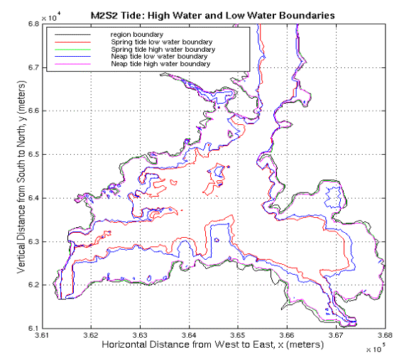
Figure 8-1. High water and low water boundaries for the M2S2 tide. The high water boundary is shown in green and the low water boundary is shown in red for the spring tide. The high water boundary is shown in pink and the low water boundary is shown in blue for the neap tide.
The model results at specified stations are compared with the tidal analysis predicted time series. Figure 8-2 shows the comparison of the surface elevation time series at stations T-UNH and T-19 and the comparison of cross-section averaged velocity time series at station C-131, respectively. The model predictions compare well with the tidal analysis predicted data at those stations. The statistical analysis of those comparisons are given in Table 8-2.
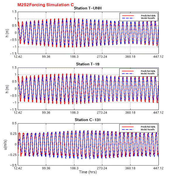
Figure 8-2. M2S2 forcing: Comparison of model predicted time series and tidal analysis predicted data at stations T-UNH, T-19 and C-131. Top figure shows the comparisons of the surface elevation time series at station T-UNH. Second figure shows the comparison of the surface elevation time series at station T-19. The bottom figure shows the comparison of cross-section averaged velocity time series at station C-131.
Table 8-2. Statistical analysis results for the
M2S2 forcing in Great Bay.
|
|
Station
T-UNH |
Station T-19 |
Station C-131 |
|
Correlation Coef. |
0.98 |
0.98 |
0.96 |
|
Skill |
0.96 |
0.95 |
0.92 |
|
RMSN |
0.20 |
0.22 |
0.28 |
8.2 Eelgrass Effects on the M2S2 Tidal Flow in Great Bay
The same 1990 eelgrass distribution explained in Chapter 7 is used for the M2S2 simulation. The effects observed are as follows:
· During the spring tide, the water surface of Great Bay covers 19.19 km2 (9852 elements) at high water and 10.03 km2 (4602 elements) at low water. The average depth is 2.68m for high water and 2.01m for low water. The average depth at low water with eelgrass is 7cm lower than the average depth at low water without any eelgrass. Also the water surface area at low water with eelgrass is 0.4 km2 (208 elements) larger than the water surface area at low water without eelgrass. There was no significant change in the surface area and the average depth values at high water.
· During the neap tide, the water surface of Great Bay covers 18.99 km2 (9694 elements) at high water and 12.37 km2 (5612 elements) at low water. The average depth is 2.53m for high water and 1.77m for low water. The average depth at low water with eelgrass is 15cm lower than average depth at low water without any eelgrass. Also the water surface area at low water with eelgrass is 0.96 km2 (410 elements) larger than the water surface area at low water without eelgrass. There was no significant change in the surface area and the average depth values at high water.
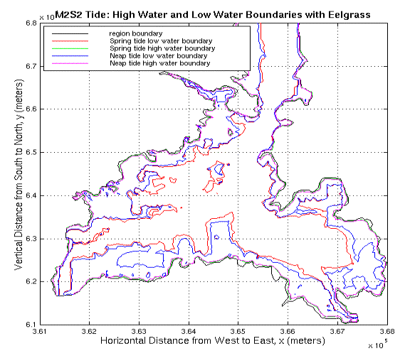
Figure 8-3. High water and low water boundaries for the M2S2 tide with eelgrass. The high water boundary is shown in green and the low water boundary is shown in red for the spring tide. The high water boundary is shown in pink and the low water boundary is shown in blue for the neap tide.
The difference in the water volume time series between the simulation without eelgrass and the simulation with eelgrass is shown in Figure 8-4.
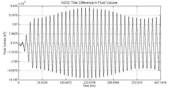
Figure 8-4. The difference in water volume time series between the simulation with eelgrass and the simulation without eelgrass for the M2S2 tide. Flood is in the negative direction.
When there is no eelgrass distribution, 590000 m3 more water enters and 650000 m3 more water exits the system at spring tide. This means that eelgrass blocks the water entering the system, and once the high water stage is reached eelgrass holds the water and blocks it from exiting the system.
8.2.1 Eelgrass Effects on the M2S2 Tidal Flow at Spring Tide
The previous twenty-seven (27) arbitrary
stations in Great Bay are used in order to observe the frictional effects of
eelgrass on the M2S2 tidal flow during the Spring tide.
The changes in velocity magnitudes and directions are shown in Figure 8-5 through Figure
8-7 over the Spring cycle.
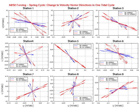
Figure 8-5. M2S2 forcing: Comparison between model-predicted velocity vectors with eelgrass and the model-predicted velocity vectors without eelgrass at stations 1-9 for the spring tide. Eelgrass simulation results are shown with blue vectors.
Stations 1-13 and station 26 are all on the tidal flats. The velocities at those stations are decreased and changed direction towards the deep channels when there is eelgrass on the tidal flats. Station 15 is in the Furber Strait far from the eelgrass effects and no velocity change due to eelgrass is observed at this station. The velocities at stations 16-27, except station 26, are increased as they are located in the channels.
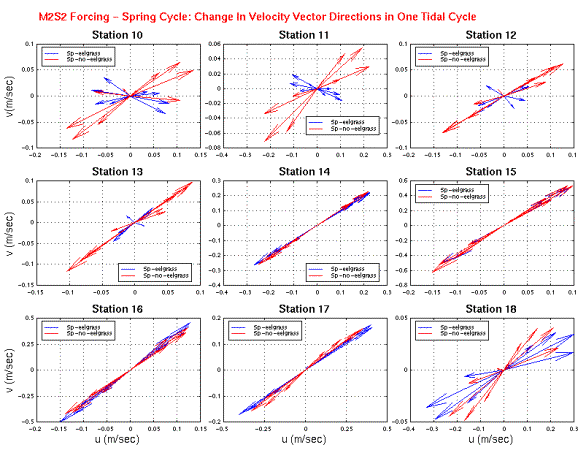
Figure 8-6. M2S2 forcing: Comparison between model-predicted velocity vectors with eelgrass and the model-predicted velocity vectors without eelgrass at stations 10-18 for the spring tide. Eelgrass simulation results are shown with blue vectors.
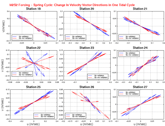
Figure 8-7. M2S2 forcing: Comparison between model-predicted velocity vectors with eelgrass and the model-predicted velocity vectors without eelgrass at stations 19-27 for the spring tide. Eelgrass simulation results are shown with blue vectors.
The velocity vectors were explored at the maximum ebb and maximum flood stages with and without eelgrass. The changes observed in velocity magnitudes and directions on the tidal flats and the deep channels are shown in Figure 8-8 and Figure 8-9.
The velocity distribution in the south east Great Bay around an eelgrass bed is shown in Figure 8-8. The velocity vectors on the tidal flat outside the eelgrass bed are directed around the eelgrass bed towards the channel in the west. When there is eelgrass, the velocity values over the eelgrass bed are decreased while the velocity vectors are increased in between the eelgrass beds.
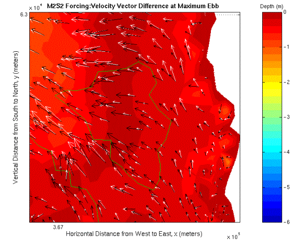
Figure 8-8. M2S2 forcing: Difference in current vectors at maximum ebb in the south east Great Bay around an eelgrass bed. Velocities calculated without eelgrass distribution are shown with black vectors. White vectors indicate the velocities when there is eelgrass. The eelgrass bed is surrounded by a green contour.
The velocity distribution around an eelgrass bed in the west Great Bay is shown in Figure 8-9. When there is eelgrass, the velocity values over the eelgrass bed are decreased and directed towards the nearest channel while the velocity vectors are increased in the channel.
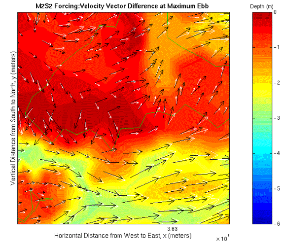
Figure 8-9. M2S2 forcing: Difference in current vectors at maximum ebb in the west Great Bay around an eelgrass bed. Velocities calculated without eelgrass distribution are shown with black vectors. White vectors indicate the velocities when there is eelgrass. The eelgrass bed is surrounded by a green contour.
8.2.2 Eelgrass Effects on the M2S2 Tidal Flow at Neap Tide
The same twenty-seven (27) arbitrary stations in Great Bay are used in order to observe the frictional effects of eelgrass on the M2S2 tidal flow during the Neap tide. The changes in velocity magnitudes and directions are shown in Figure 8-10 through Figure 8-12 over the Neap cycle.
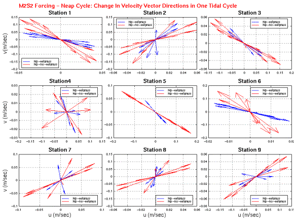
Figure 8-10. M2S2 forcing: Comparison between model-predicted velocity vectors with eelgrass and the model-predicted velocity vectors without eelgrass at stations 1-9 for the neap tide. Eelgrass simulation results are shown with blue vectors.
Stations 1-13 and station 26 are all on the tidal flats. The velocities at those stations are decreased and changed direction towards the deep channels when there is eelgrass on the tidal flats. Station 15 is in the Furber Strait far from the eelgrass effects and no velocity change due to eelgrass is observed at this station. The velocities at stations 16-27, except station 26, are increased as they are located in the channels.
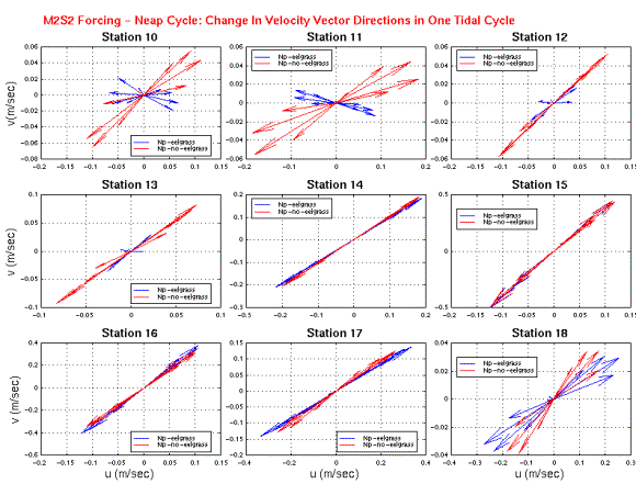
Figure 8-11. M2S2 forcing: Comparison between model-predicted velocity vectors with eelgrass and the model-predicted velocity vectors without eelgrass at stations 10-18 for the neap tide. Eelgrass simulation results are shown with blue vectors.
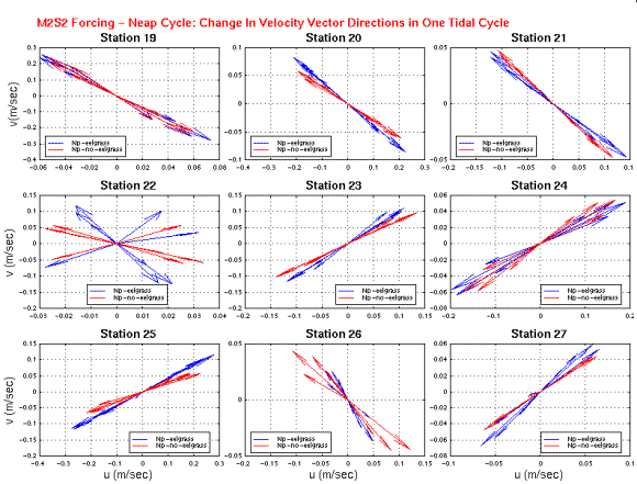
Figure 8-12. M2S2 forcing: Comparison between model-predicted velocity vectors with eelgrass and the model-predicted velocity vectors without eelgrass at stations 19-27 for the neap tide. Eelgrass simulation results are shown with blue vectors.
The results for the Spring and the Neap tides show that the frictional effects of eelgrass on the tidal flow is consistent. In the next chapter, the M2S2N2 tidal flow will be examined with the eelgrass effects.

![[back]](../images/home.gif)